You are here: Home > Network List > TA - USArray Transportable Network (new EarthScope stations) Stations List
> Station U59A Littleton, NC, USA > Earthquake Result Viewer
U59A Littleton, NC, USA - Earthquake Result Viewer
| Earthquake location: |
Near Coast Of Northern Chile |
| Earthquake latitude/longitude: |
-19.6/-70.8 |
| Earthquake time(UTC): |
2014/04/01 (091) 23:46:46 GMT |
| Earthquake Depth: |
20 km |
| Earthquake Magnitude: |
8.2 MWW, 8.0 MI, 8.1 MWC |
| Earthquake Catalog/Contributor: |
NEIC PDE/NEIC COMCAT |
|
| Network: |
TA USArray Transportable Network (new EarthScope stations) |
| Station: |
U59A Littleton, NC, USA |
| Lat/Lon: |
36.35 N/77.79 W |
| Elevation: |
99 m |
|
| Distance: |
56.1 deg |
| Az: |
353.215 deg |
| Baz: |
172.071 deg |
| Ray Param: |
0.064351894 |
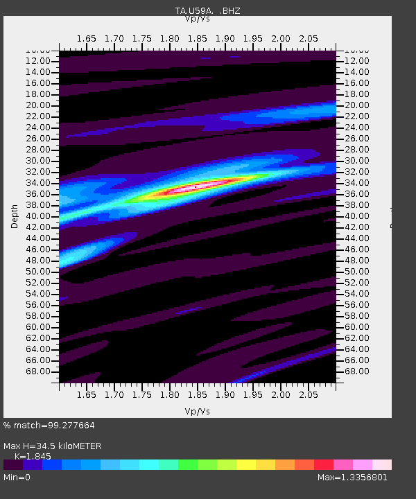
| Estimated Moho Depth: |
34.5 km |
| Estimated Crust Vp/Vs: |
1.85 |
| Assumed Crust Vp: |
6.565 km/s |
| Estimated Crust Vs: |
3.558 km/s |
| Estimated Crust Poisson's Ratio: |
0.29 |
|
| Radial Match: |
99.277664 % |
| Radial Bump: |
254 |
| Transverse Match: |
90.567085 % |
| Transverse Bump: |
400 |
| SOD ConfigId: |
626651 |
| Insert Time: |
2014-04-21 19:09:39.637 +0000 |
| GWidth: |
2.5 |
| Max Bumps: |
400 |
| Tol: |
0.001 |
|
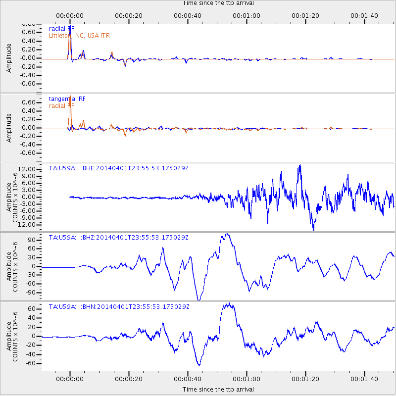
Signal To Noise
| Channel | StoN | STA | LTA |
| TA:U59A: :BHZ:20140401T23:55:53.175029Z | 17.30425 | 2.7985927E-6 | 1.6172864E-7 |
| TA:U59A: :BHN:20140401T23:55:53.175029Z | 9.164152 | 1.4572485E-6 | 1.5901618E-7 |
| TA:U59A: :BHE:20140401T23:55:53.175029Z | 1.3327497 | 2.4760837E-7 | 1.857876E-7 |
| Arrivals |
| Ps | 4.7 SECOND |
| PpPs | 14 SECOND |
| PsPs/PpSs | 19 SECOND |


