You are here: Home > Network List > TA - USArray Transportable Network (new EarthScope stations) Stations List
> Station V57A Coltrane Farms, NC, USA > Earthquake Result Viewer
V57A Coltrane Farms, NC, USA - Earthquake Result Viewer
| Earthquake location: |
Near Coast Of Northern Chile |
| Earthquake latitude/longitude: |
-19.6/-70.8 |
| Earthquake time(UTC): |
2014/04/01 (091) 23:46:46 GMT |
| Earthquake Depth: |
20 km |
| Earthquake Magnitude: |
8.2 MWW, 8.0 MI, 8.1 MWC |
| Earthquake Catalog/Contributor: |
NEIC PDE/NEIC COMCAT |
|
| Network: |
TA USArray Transportable Network (new EarthScope stations) |
| Station: |
V57A Coltrane Farms, NC, USA |
| Lat/Lon: |
35.89 N/79.78 W |
| Elevation: |
223 m |
|
| Distance: |
55.9 deg |
| Az: |
351.213 deg |
| Baz: |
169.787 deg |
| Ray Param: |
0.06448543 |
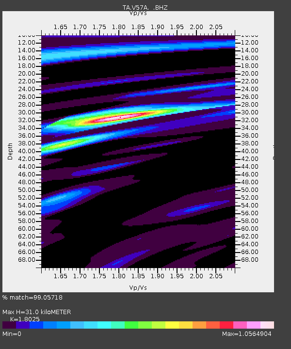
| Estimated Moho Depth: |
31.0 km |
| Estimated Crust Vp/Vs: |
1.80 |
| Assumed Crust Vp: |
6.565 km/s |
| Estimated Crust Vs: |
3.642 km/s |
| Estimated Crust Poisson's Ratio: |
0.28 |
|
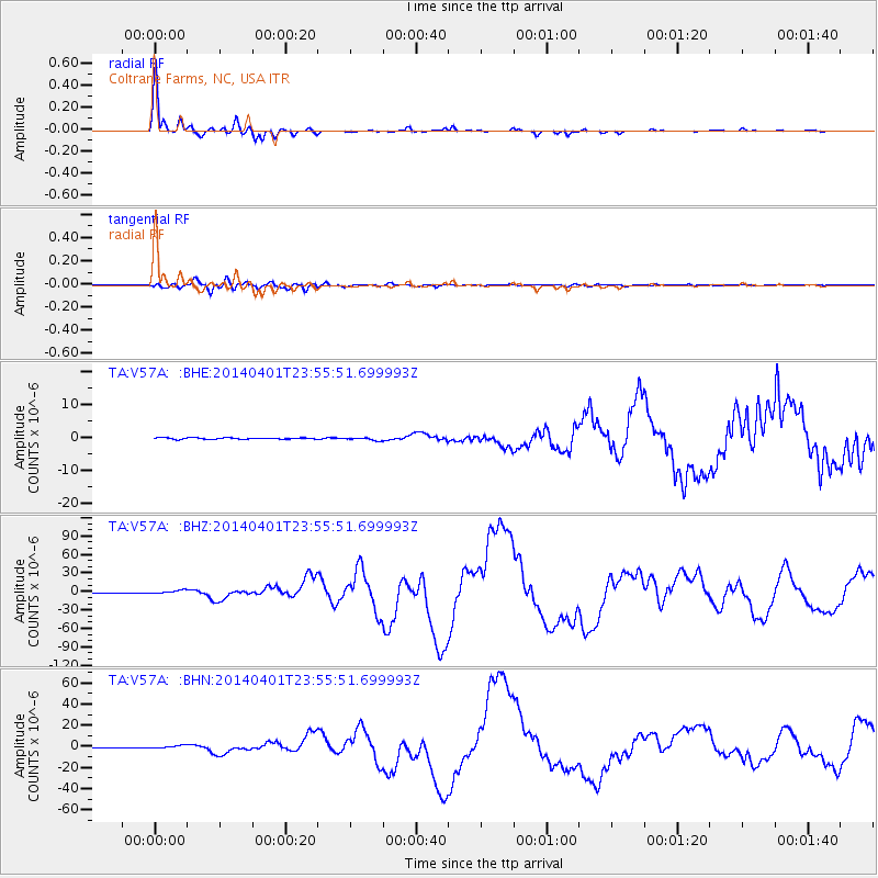
| Radial Match: |
99.05718 % |
| Radial Bump: |
340 |
| Transverse Match: |
94.44682 % |
| Transverse Bump: |
400 |
| SOD ConfigId: |
626651 |
| Insert Time: |
2014-04-21 19:10:00.638 +0000 |
| GWidth: |
2.5 |
| Max Bumps: |
400 |
| Tol: |
0.001 |
|
Signal To Noise
| Channel | StoN | STA | LTA |
| TA:V57A: :BHZ:20140401T23:55:51.699993Z | 13.11493 | 2.611473E-6 | 1.9912216E-7 |
| TA:V57A: :BHN:20140401T23:55:51.699993Z | 8.678611 | 1.2965686E-6 | 1.4939816E-7 |
| TA:V57A: :BHE:20140401T23:55:51.699993Z | 2.0056593 | 4.291338E-7 | 2.1396146E-7 |
| Arrivals |
| Ps | 4.0 SECOND |
| PpPs | 13 SECOND |
| PsPs/PpSs | 17 SECOND |


