You are here: Home > Network List > TA - USArray Transportable Network (new EarthScope stations) Stations List
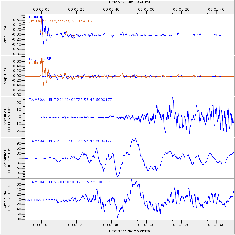
> Station V60A Jim Taylor Road, Stokes, NC, USA > Earthquake Result Viewer
V60A Jim Taylor Road, Stokes, NC, USA - Earthquake Result Viewer
| Earthquake location: |
Near Coast Of Northern Chile |
| Earthquake latitude/longitude: |
-19.6/-70.8 |
| Earthquake time(UTC): |
2014/04/01 (091) 23:46:46 GMT |
| Earthquake Depth: |
20 km |
| Earthquake Magnitude: |
8.2 MWW, 8.0 MI, 8.1 MWC |
| Earthquake Catalog/Contributor: |
NEIC PDE/NEIC COMCAT |
|
| Network: |
TA USArray Transportable Network (new EarthScope stations) |
| Station: |
V60A Jim Taylor Road, Stokes, NC, USA |
| Lat/Lon: |
35.76 N/77.26 W |
| Elevation: |
8.0 m |
|
| Distance: |
55.4 deg |
| Az: |
353.635 deg |
| Baz: |
172.618 deg |
| Ray Param: |
0.0647674 |
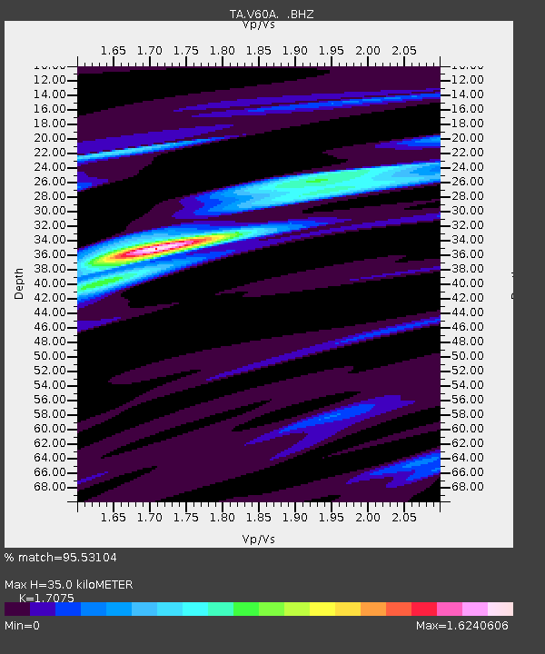
| Estimated Moho Depth: |
35.0 km |
| Estimated Crust Vp/Vs: |
1.71 |
| Assumed Crust Vp: |
6.565 km/s |
| Estimated Crust Vs: |
3.845 km/s |
| Estimated Crust Poisson's Ratio: |
0.24 |
|
| Radial Match: |
95.53104 % |
| Radial Bump: |
400 |
| Transverse Match: |
64.79281 % |
| Transverse Bump: |
400 |
| SOD ConfigId: |
626651 |
| Insert Time: |
2014-04-21 19:10:14.575 +0000 |
| GWidth: |
2.5 |
| Max Bumps: |
400 |
| Tol: |
0.001 |
|
Signal To Noise
| Channel | StoN | STA | LTA |
| TA:V60A: :BHZ:20140401T23:55:48.600017Z | 9.78245 | 2.6954515E-6 | 2.755395E-7 |
| TA:V60A: :BHN:20140401T23:55:48.600017Z | 2.6950517 | 1.4462659E-6 | 5.366376E-7 |
| TA:V60A: :BHE:20140401T23:55:48.600017Z | 0.97522295 | 3.6614236E-7 | 3.7544478E-7 |
| Arrivals |
| Ps | 4.0 SECOND |
| PpPs | 14 SECOND |
| PsPs/PpSs | 18 SECOND |


