You are here: Home > Network List > TA - USArray Transportable Network (new EarthScope stations) Stations List
> Station X57A Johnson Farm, Hartsville, SC, USA > Earthquake Result Viewer
X57A Johnson Farm, Hartsville, SC, USA - Earthquake Result Viewer
| Earthquake location: |
Near Coast Of Northern Chile |
| Earthquake latitude/longitude: |
-19.6/-70.8 |
| Earthquake time(UTC): |
2014/04/01 (091) 23:46:46 GMT |
| Earthquake Depth: |
20 km |
| Earthquake Magnitude: |
8.2 MWW, 8.0 MI, 8.1 MWC |
| Earthquake Catalog/Contributor: |
NEIC PDE/NEIC COMCAT |
|
| Network: |
TA USArray Transportable Network (new EarthScope stations) |
| Station: |
X57A Johnson Farm, Hartsville, SC, USA |
| Lat/Lon: |
34.46 N/80.09 W |
| Elevation: |
133 m |
|
| Distance: |
54.5 deg |
| Az: |
350.587 deg |
| Baz: |
169.247 deg |
| Ray Param: |
0.06537032 |
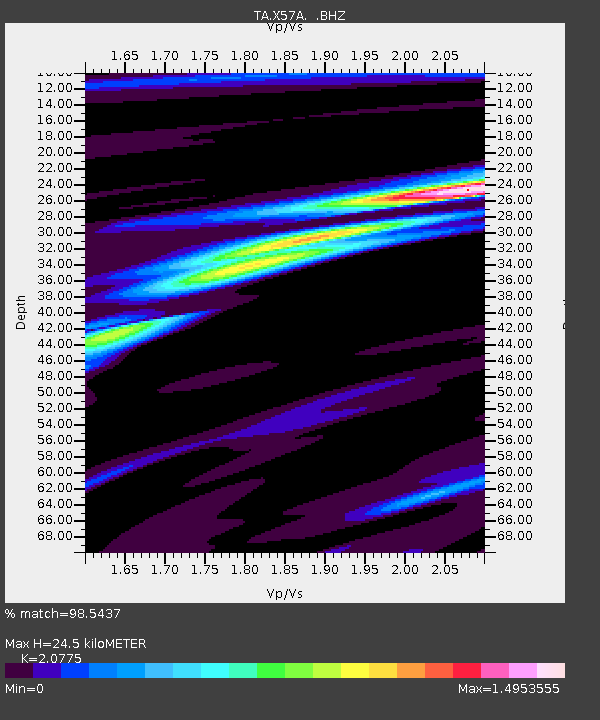
| Estimated Moho Depth: |
24.5 km |
| Estimated Crust Vp/Vs: |
2.08 |
| Assumed Crust Vp: |
6.419 km/s |
| Estimated Crust Vs: |
3.09 km/s |
| Estimated Crust Poisson's Ratio: |
0.35 |
|
| Radial Match: |
98.5437 % |
| Radial Bump: |
284 |
| Transverse Match: |
76.701866 % |
| Transverse Bump: |
400 |
| SOD ConfigId: |
626651 |
| Insert Time: |
2014-04-21 19:11:40.384 +0000 |
| GWidth: |
2.5 |
| Max Bumps: |
400 |
| Tol: |
0.001 |
|
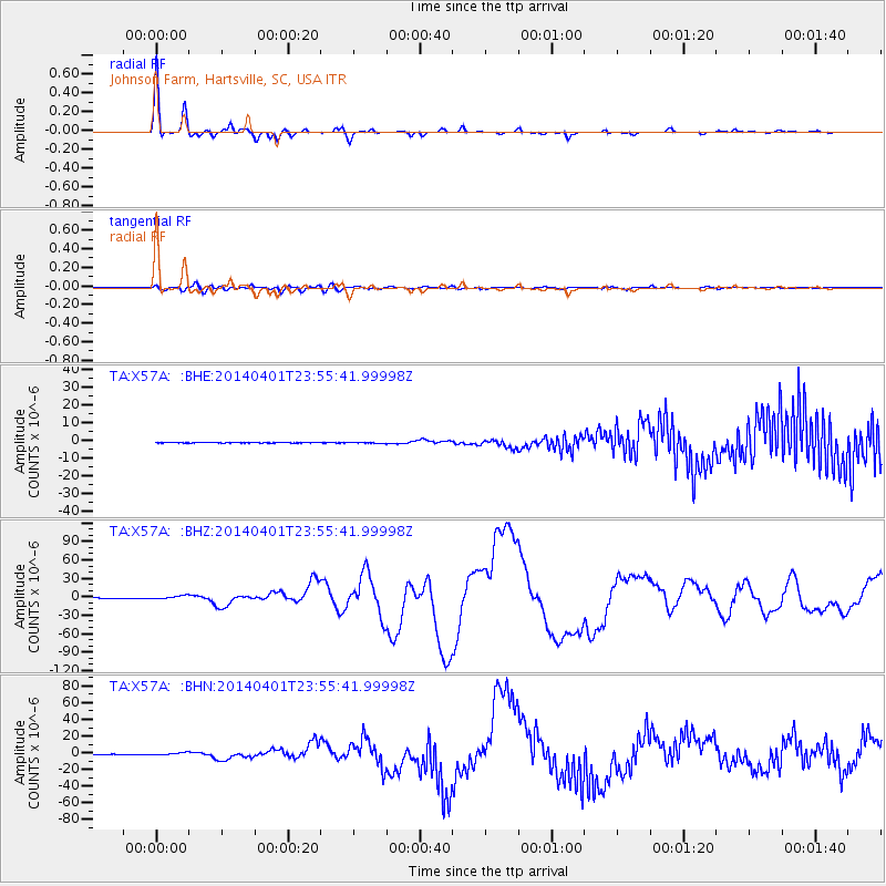
Signal To Noise
| Channel | StoN | STA | LTA |
| TA:X57A: :BHZ:20140401T23:55:41.99998Z | 11.478335 | 2.6289915E-6 | 2.2903944E-7 |
| TA:X57A: :BHN:20140401T23:55:41.99998Z | 5.674403 | 1.377259E-6 | 2.4271432E-7 |
| TA:X57A: :BHE:20140401T23:55:41.99998Z | 1.7231802 | 2.6495766E-7 | 1.5376085E-7 |
| Arrivals |
| Ps | 4.3 SECOND |
| PpPs | 11 SECOND |
| PsPs/PpSs | 16 SECOND |


