You are here: Home > Network List > TA - USArray Transportable Network (new EarthScope stations) Stations List
> Station X58A Rowland, NC, USA > Earthquake Result Viewer
X58A Rowland, NC, USA - Earthquake Result Viewer

| Earthquake location: |
Near Coast Of Northern Chile |
| Earthquake latitude/longitude: |
-19.6/-70.8 |
| Earthquake time(UTC): |
2014/04/01 (091) 23:46:46 GMT |
| Earthquake Depth: |
20 km |
| Earthquake Magnitude: |
8.2 MWW, 8.0 MI, 8.1 MWC |
| Earthquake Catalog/Contributor: |
NEIC PDE/NEIC COMCAT |
|
| Network: |
TA USArray Transportable Network (new EarthScope stations) |
| Station: |
X58A Rowland, NC, USA |
| Lat/Lon: |
34.55 N/79.34 W |
| Elevation: |
45 m |
|
| Distance: |
54.5 deg |
| Az: |
351.36 deg |
| Baz: |
170.122 deg |
| Ray Param: |
0.06538458 |
| Estimated Moho Depth: |
35.75 km |
| Estimated Crust Vp/Vs: |
1.72 |
| Assumed Crust Vp: |
6.565 km/s |
| Estimated Crust Vs: |
3.817 km/s |
| Estimated Crust Poisson's Ratio: |
0.24 |
|
| Radial Match: |
98.621506 % |
| Radial Bump: |
398 |
| Transverse Match: |
84.53218 % |
| Transverse Bump: |
400 |
| SOD ConfigId: |
626651 |
| Insert Time: |
2014-04-21 19:11:41.307 +0000 |
| GWidth: |
2.5 |
| Max Bumps: |
400 |
| Tol: |
0.001 |
|
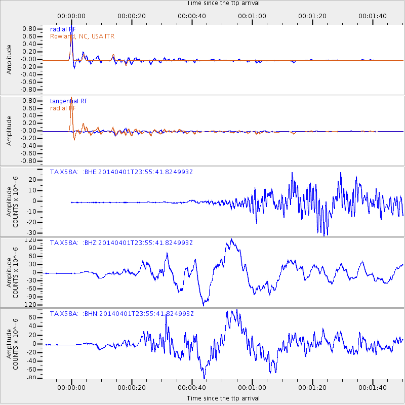
Signal To Noise
| Channel | StoN | STA | LTA |
| TA:X58A: :BHZ:20140401T23:55:41.824993Z | 10.680912 | 2.6865607E-6 | 2.5152914E-7 |
| TA:X58A: :BHN:20140401T23:55:41.824993Z | 6.988137 | 1.4144639E-6 | 2.024093E-7 |
| TA:X58A: :BHE:20140401T23:55:41.824993Z | 2.5890765 | 3.56417E-7 | 1.3766183E-7 |
| Arrivals |
| Ps | 4.2 SECOND |
| PpPs | 14 SECOND |
| PsPs/PpSs | 18 SECOND |


