You are here: Home > Network List > TA - USArray Transportable Network (new EarthScope stations) Stations List
> Station Y58A Scranton, SC, USA > Earthquake Result Viewer
Y58A Scranton, SC, USA - Earthquake Result Viewer
| Earthquake location: |
Near Coast Of Northern Chile |
| Earthquake latitude/longitude: |
-19.6/-70.8 |
| Earthquake time(UTC): |
2014/04/01 (091) 23:46:46 GMT |
| Earthquake Depth: |
20 km |
| Earthquake Magnitude: |
8.2 MWW, 8.0 MI, 8.1 MWC |
| Earthquake Catalog/Contributor: |
NEIC PDE/NEIC COMCAT |
|
| Network: |
TA USArray Transportable Network (new EarthScope stations) |
| Station: |
Y58A Scranton, SC, USA |
| Lat/Lon: |
33.91 N/79.67 W |
| Elevation: |
19 m |
|
| Distance: |
53.9 deg |
| Az: |
350.89 deg |
| Baz: |
169.664 deg |
| Ray Param: |
0.065756716 |
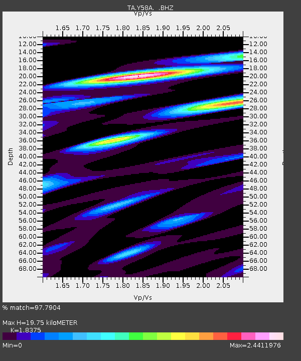
| Estimated Moho Depth: |
19.75 km |
| Estimated Crust Vp/Vs: |
1.84 |
| Assumed Crust Vp: |
6.24 km/s |
| Estimated Crust Vs: |
3.396 km/s |
| Estimated Crust Poisson's Ratio: |
0.29 |
|
| Radial Match: |
97.7904 % |
| Radial Bump: |
400 |
| Transverse Match: |
91.41912 % |
| Transverse Bump: |
400 |
| SOD ConfigId: |
626651 |
| Insert Time: |
2014-04-21 19:12:19.446 +0000 |
| GWidth: |
2.5 |
| Max Bumps: |
400 |
| Tol: |
0.001 |
|
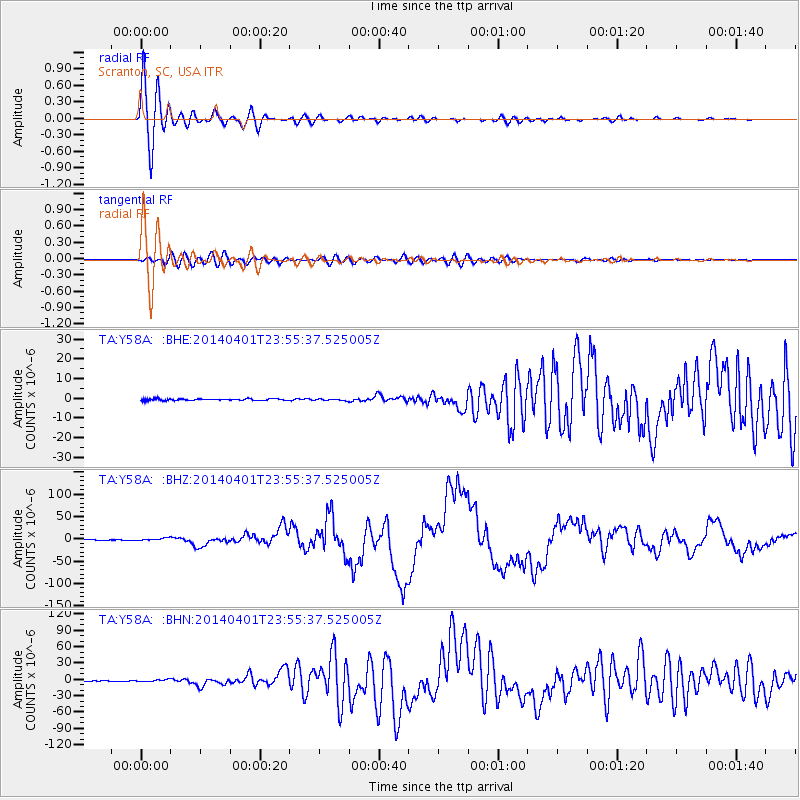
Signal To Noise
| Channel | StoN | STA | LTA |
| TA:Y58A: :BHZ:20140401T23:55:37.525005Z | 12.185526 | 2.8137442E-6 | 2.3090873E-7 |
| TA:Y58A: :BHN:20140401T23:55:37.525005Z | 4.1594577 | 1.73786E-6 | 4.1780925E-7 |
| TA:Y58A: :BHE:20140401T23:55:37.525005Z | 0.9630851 | 3.8846267E-7 | 4.0335237E-7 |
| Arrivals |
| Ps | 2.8 SECOND |
| PpPs | 8.6 SECOND |
| PsPs/PpSs | 11 SECOND |


