You are here: Home > Network List > TA - USArray Transportable Network (new EarthScope stations) Stations List
> Station Y59A Loris, SC, USA > Earthquake Result Viewer
Y59A Loris, SC, USA - Earthquake Result Viewer
| Earthquake location: |
Near Coast Of Northern Chile |
| Earthquake latitude/longitude: |
-19.6/-70.8 |
| Earthquake time(UTC): |
2014/04/01 (091) 23:46:46 GMT |
| Earthquake Depth: |
20 km |
| Earthquake Magnitude: |
8.2 MWW, 8.0 MI, 8.1 MWC |
| Earthquake Catalog/Contributor: |
NEIC PDE/NEIC COMCAT |
|
| Network: |
TA USArray Transportable Network (new EarthScope stations) |
| Station: |
Y59A Loris, SC, USA |
| Lat/Lon: |
33.99 N/78.87 W |
| Elevation: |
2.0 m |
|
| Distance: |
53.9 deg |
| Az: |
351.712 deg |
| Baz: |
170.588 deg |
| Ray Param: |
0.06577714 |
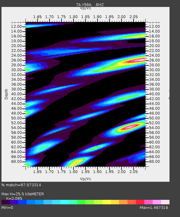
| Estimated Moho Depth: |
25.5 km |
| Estimated Crust Vp/Vs: |
2.10 |
| Assumed Crust Vp: |
6.24 km/s |
| Estimated Crust Vs: |
2.979 km/s |
| Estimated Crust Poisson's Ratio: |
0.35 |
|
| Radial Match: |
97.873314 % |
| Radial Bump: |
400 |
| Transverse Match: |
84.19564 % |
| Transverse Bump: |
400 |
| SOD ConfigId: |
626651 |
| Insert Time: |
2014-04-21 19:12:21.931 +0000 |
| GWidth: |
2.5 |
| Max Bumps: |
400 |
| Tol: |
0.001 |
|

Signal To Noise
| Channel | StoN | STA | LTA |
| TA:Y59A: :BHZ:20140401T23:55:37.300029Z | 8.743868 | 2.7070027E-6 | 3.095887E-7 |
| TA:Y59A: :BHN:20140401T23:55:37.300029Z | 3.8696578 | 1.3723483E-6 | 3.5464333E-7 |
| TA:Y59A: :BHE:20140401T23:55:37.300029Z | 0.6884973 | 2.6322144E-7 | 3.8231298E-7 |
| Arrivals |
| Ps | 4.7 SECOND |
| PpPs | 12 SECOND |
| PsPs/PpSs | 17 SECOND |


