You are here: Home > Network List > US - United States National Seismic Network Stations List
> Station AMTX Amarillo, Texas, USA > Earthquake Result Viewer
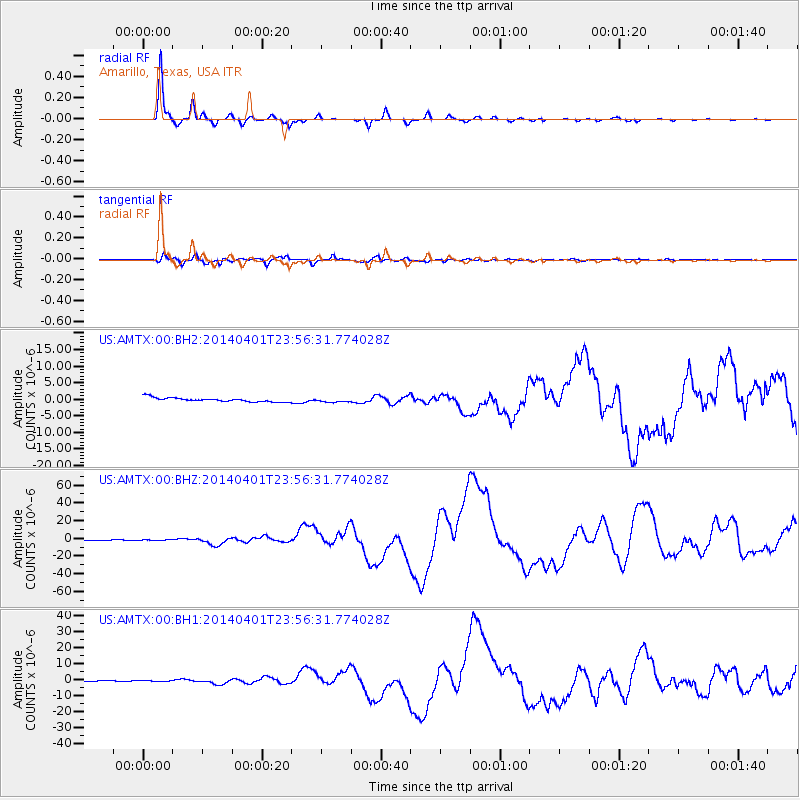
AMTX Amarillo, Texas, USA - Earthquake Result Viewer
*The percent match for this event was below the threshold and hence no stack was calculated.
| Earthquake location: |
Near Coast Of Northern Chile |
| Earthquake latitude/longitude: |
-19.6/-70.8 |
| Earthquake time(UTC): |
2014/04/01 (091) 23:46:46 GMT |
| Earthquake Depth: |
20 km |
| Earthquake Magnitude: |
8.2 MWW, 8.0 MI, 8.1 MWC |
| Earthquake Catalog/Contributor: |
NEIC PDE/NEIC COMCAT |
|
| Network: |
US United States National Seismic Network |
| Station: |
AMTX Amarillo, Texas, USA |
| Lat/Lon: |
34.53 N/101.41 W |
| Elevation: |
1010 m |
|
| Distance: |
61.2 deg |
| Az: |
331.358 deg |
| Baz: |
146.824 deg |
| Ray Param: |
$rayparam |
*The percent match for this event was below the threshold and hence was not used in the summary stack. |
|
| Radial Match: |
98.96354 % |
| Radial Bump: |
214 |
| Transverse Match: |
93.38905 % |
| Transverse Bump: |
400 |
| SOD ConfigId: |
626651 |
| Insert Time: |
2014-04-21 19:13:42.480 +0000 |
| GWidth: |
2.5 |
| Max Bumps: |
400 |
| Tol: |
0.001 |
|
Signal To Noise
| Channel | StoN | STA | LTA |
| US:AMTX:00:BHZ:20140401T23:56:31.774028Z | 2.4836166 | 4.092984E-7 | 1.6479935E-7 |
| US:AMTX:00:BH1:20140401T23:56:31.774028Z | 1.3511871 | 3.5215118E-7 | 2.6062352E-7 |
| US:AMTX:00:BH2:20140401T23:56:31.774028Z | 1.3071448 | 7.5645846E-7 | 5.787105E-7 |
| Arrivals |
| Ps | |
| PpPs | |
| PsPs/PpSs | |


