You are here: Home > Network List > UW - Pacific Northwest Regional Seismic Network Stations List
> Station IZEE Izee, OR, USA > Earthquake Result Viewer
IZEE Izee, OR, USA - Earthquake Result Viewer

| Earthquake location: |
Near Coast Of Northern Chile |
| Earthquake latitude/longitude: |
-19.6/-70.8 |
| Earthquake time(UTC): |
2014/04/01 (091) 23:46:46 GMT |
| Earthquake Depth: |
20 km |
| Earthquake Magnitude: |
8.2 MWW, 8.0 MI, 8.1 MWC |
| Earthquake Catalog/Contributor: |
NEIC PDE/NEIC COMCAT |
|
| Network: |
UW Pacific Northwest Regional Seismic Network |
| Station: |
IZEE Izee, OR, USA |
| Lat/Lon: |
44.08 N/119.50 W |
| Elevation: |
1293 m |
|
| Distance: |
77.5 deg |
| Az: |
326.324 deg |
| Baz: |
133.515 deg |
| Ray Param: |
0.050274905 |
| Estimated Moho Depth: |
28.0 km |
| Estimated Crust Vp/Vs: |
2.04 |
| Assumed Crust Vp: |
6.571 km/s |
| Estimated Crust Vs: |
3.221 km/s |
| Estimated Crust Poisson's Ratio: |
0.34 |
|
| Radial Match: |
98.58019 % |
| Radial Bump: |
163 |
| Transverse Match: |
87.88813 % |
| Transverse Bump: |
400 |
| SOD ConfigId: |
626651 |
| Insert Time: |
2014-04-21 19:22:16.189 +0000 |
| GWidth: |
2.5 |
| Max Bumps: |
400 |
| Tol: |
0.001 |
|
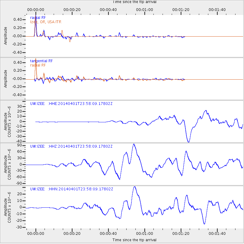
Signal To Noise
| Channel | StoN | STA | LTA |
| UW:IZEE: :HHZ:20140401T23:58:09.17802Z | 1.4371656 | 5.4606886E-7 | 3.799624E-7 |
| UW:IZEE: :HHN:20140401T23:58:09.17802Z | 0.98224443 | 2.5781503E-7 | 2.6247545E-7 |
| UW:IZEE: :HHE:20140401T23:58:09.17802Z | 1.3089039 | 2.0919437E-7 | 1.5982408E-7 |
| Arrivals |
| Ps | 4.6 SECOND |
| PpPs | 13 SECOND |
| PsPs/PpSs | 17 SECOND |


