You are here: Home > Network List > CI - Caltech Regional Seismic Network Stations List
> Station BAR Barrett, Tecate, CA, USA > Earthquake Result Viewer
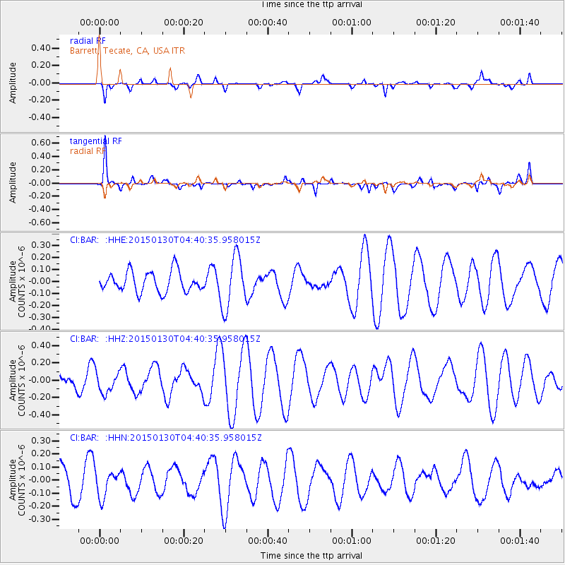
BAR Barrett, Tecate, CA, USA - Earthquake Result Viewer
*The percent match for this event was below the threshold and hence no stack was calculated.
| Earthquake location: |
Kuril Islands |
| Earthquake latitude/longitude: |
49.4/156.4 |
| Earthquake time(UTC): |
2015/01/30 (030) 04:30:37 GMT |
| Earthquake Depth: |
46 km |
| Earthquake Magnitude: |
5.2 MW, 5.0 mb, 4.7 MS |
| Earthquake Catalog/Contributor: |
ISC/ISC |
|
| Network: |
CI Caltech Regional Seismic Network |
| Station: |
BAR Barrett, Tecate, CA, USA |
| Lat/Lon: |
32.68 N/116.67 W |
| Elevation: |
521 m |
|
| Distance: |
64.1 deg |
| Az: |
69.39 deg |
| Baz: |
313.479 deg |
| Ray Param: |
$rayparam |
*The percent match for this event was below the threshold and hence was not used in the summary stack. |
|
| Radial Match: |
40.95538 % |
| Radial Bump: |
329 |
| Transverse Match: |
73.53144 % |
| Transverse Bump: |
376 |
| SOD ConfigId: |
3390531 |
| Insert Time: |
2019-04-16 05:33:43.632 +0000 |
| GWidth: |
2.5 |
| Max Bumps: |
400 |
| Tol: |
0.001 |
|
Signal To Noise
| Channel | StoN | STA | LTA |
| CI:BAR: :HHZ:20150130T04:40:35.958015Z | 0.82880414 | 1.14424665E-7 | 1.3805995E-7 |
| CI:BAR: :HHN:20150130T04:40:35.958015Z | 0.69339573 | 9.732782E-8 | 1.4036404E-7 |
| CI:BAR: :HHE:20150130T04:40:35.958015Z | 2.6177526 | 2.2261744E-7 | 8.504144E-8 |
| Arrivals |
| Ps | |
| PpPs | |
| PsPs/PpSs | |


