You are here: Home > Network List > UW - Pacific Northwest Regional Seismic Network Stations List
> Station UMAT Pilot Rock, OR, USA > Earthquake Result Viewer
UMAT Pilot Rock, OR, USA - Earthquake Result Viewer

| Earthquake location: |
Near Coast Of Northern Chile |
| Earthquake latitude/longitude: |
-19.6/-70.8 |
| Earthquake time(UTC): |
2014/04/01 (091) 23:46:46 GMT |
| Earthquake Depth: |
20 km |
| Earthquake Magnitude: |
8.2 MWW, 8.0 MI, 8.1 MWC |
| Earthquake Catalog/Contributor: |
NEIC PDE/NEIC COMCAT |
|
| Network: |
UW Pacific Northwest Regional Seismic Network |
| Station: |
UMAT Pilot Rock, OR, USA |
| Lat/Lon: |
45.29 N/118.96 W |
| Elevation: |
1318 m |
|
| Distance: |
78.0 deg |
| Az: |
327.491 deg |
| Baz: |
134.145 deg |
| Ray Param: |
0.049896013 |
| Estimated Moho Depth: |
42.75 km |
| Estimated Crust Vp/Vs: |
1.61 |
| Assumed Crust Vp: |
6.571 km/s |
| Estimated Crust Vs: |
4.075 km/s |
| Estimated Crust Poisson's Ratio: |
0.19 |
|
| Radial Match: |
95.477745 % |
| Radial Bump: |
302 |
| Transverse Match: |
95.712776 % |
| Transverse Bump: |
224 |
| SOD ConfigId: |
626651 |
| Insert Time: |
2014-04-21 19:23:21.942 +0000 |
| GWidth: |
2.5 |
| Max Bumps: |
400 |
| Tol: |
0.001 |
|
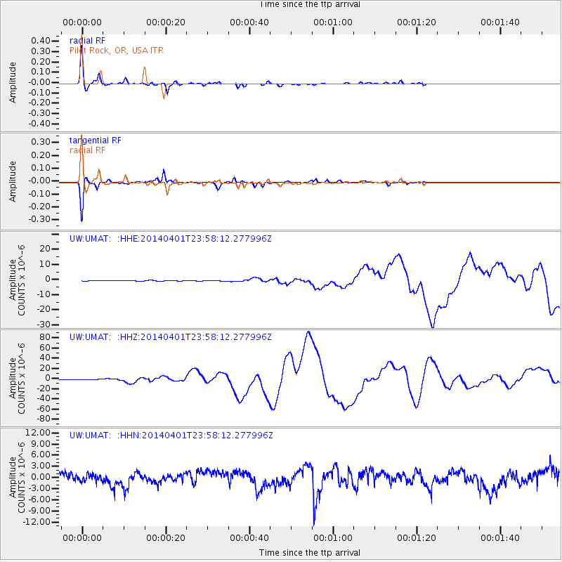
Signal To Noise
| Channel | StoN | STA | LTA |
| UW:UMAT: :HHZ:20140401T23:58:12.277996Z | 1.7513033 | 4.7546442E-7 | 2.7149176E-7 |
| UW:UMAT: :HHN:20140401T23:58:12.277996Z | 0.672766 | 9.0735546E-7 | 1.348694E-6 |
| UW:UMAT: :HHE:20140401T23:58:12.277996Z | 1.6900659 | 2.987897E-7 | 1.7679176E-7 |
| Arrivals |
| Ps | 4.1 SECOND |
| PpPs | 16 SECOND |
| PsPs/PpSs | 21 SECOND |


