You are here: Home > Network List > IU - Global Seismograph Network (GSN - IRIS/USGS) Stations List
> Station LSZ Lusaka, Zambia > Earthquake Result Viewer
LSZ Lusaka, Zambia - Earthquake Result Viewer
| Earthquake location: |
Southern Sumatra, Indonesia |
| Earthquake latitude/longitude: |
-0.7/99.9 |
| Earthquake time(UTC): |
2009/09/30 (273) 10:16:09 GMT |
| Earthquake Depth: |
81 km |
| Earthquake Magnitude: |
7.1 MB, 7.5 MW, 7.5 MW |
| Earthquake Catalog/Contributor: |
WHDF/NEIC |
|
| Network: |
IU Global Seismograph Network (GSN - IRIS/USGS) |
| Station: |
LSZ Lusaka, Zambia |
| Lat/Lon: |
15.28 S/28.19 E |
| Elevation: |
1200 m |
|
| Distance: |
72.1 deg |
| Az: |
254.27 deg |
| Baz: |
85.767 deg |
| Ray Param: |
0.053667437 |
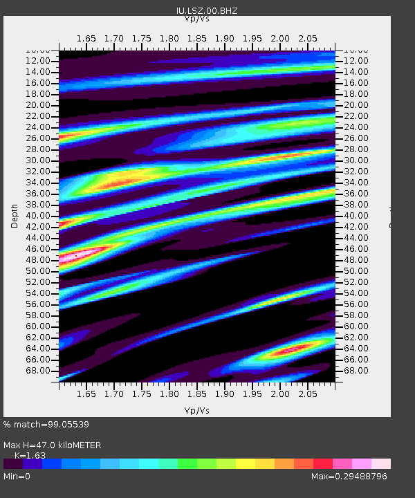
| Estimated Moho Depth: |
47.0 km |
| Estimated Crust Vp/Vs: |
1.63 |
| Assumed Crust Vp: |
6.642 km/s |
| Estimated Crust Vs: |
4.075 km/s |
| Estimated Crust Poisson's Ratio: |
0.20 |
|
| Radial Match: |
99.05539 % |
| Radial Bump: |
310 |
| Transverse Match: |
90.48934 % |
| Transverse Bump: |
400 |
| SOD ConfigId: |
1 |
| Insert Time: |
2010-02-19 00:24:37.745 +0000 |
| GWidth: |
2.5 |
| Max Bumps: |
400 |
| Tol: |
0.001 |
|

Signal To Noise
| Channel | StoN | STA | LTA |
| IU:LSZ:00:BHZ:20090930T10:26:54.27002Z | 30.738106 | 9.372417E-6 | 3.0491196E-7 |
| IU:LSZ:00:BHN:20090930T10:26:54.27002Z | 2.0511901 | 2.2441242E-7 | 1.0940596E-7 |
| IU:LSZ:00:BHE:20090930T10:26:54.27002Z | 24.672188 | 3.617281E-6 | 1.4661371E-7 |
| Arrivals |
| Ps | 4.6 SECOND |
| PpPs | 18 SECOND |
| PsPs/PpSs | 23 SECOND |


