You are here: Home > Network List > TA - USArray Transportable Network (new EarthScope stations) Stations List
> Station A04D Lummi Island, WA, USA > Earthquake Result Viewer
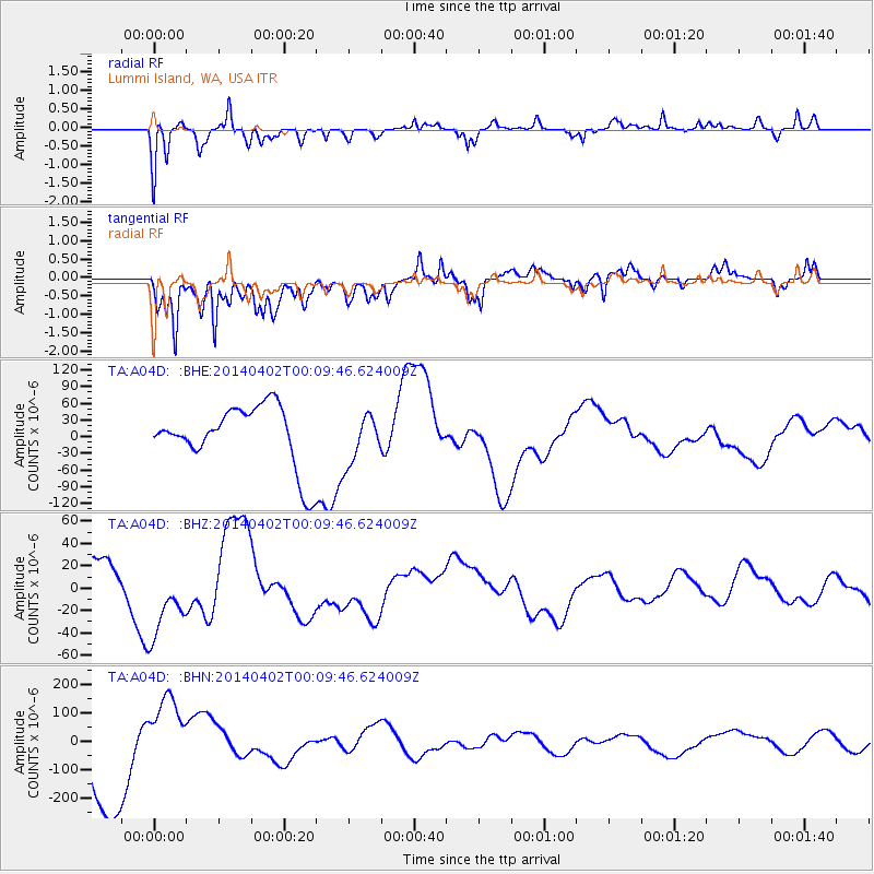
A04D Lummi Island, WA, USA - Earthquake Result Viewer
*The percent match for this event was below the threshold and hence no stack was calculated.
| Earthquake location: |
Near Coast Of Northern Chile |
| Earthquake latitude/longitude: |
-19.9/-70.9 |
| Earthquake time(UTC): |
2014/04/01 (091) 23:57:57 GMT |
| Earthquake Depth: |
20 km |
| Earthquake Magnitude: |
6.9 MWW, 6.9 MWC |
| Earthquake Catalog/Contributor: |
NEIC PDE/NEIC COMCAT |
|
| Network: |
TA USArray Transportable Network (new EarthScope stations) |
| Station: |
A04D Lummi Island, WA, USA |
| Lat/Lon: |
48.72 N/122.71 W |
| Elevation: |
13 m |
|
| Distance: |
82.4 deg |
| Az: |
328.339 deg |
| Baz: |
131.767 deg |
| Ray Param: |
$rayparam |
*The percent match for this event was below the threshold and hence was not used in the summary stack. |
|
| Radial Match: |
78.44848 % |
| Radial Bump: |
377 |
| Transverse Match: |
60.373344 % |
| Transverse Bump: |
400 |
| SOD ConfigId: |
626651 |
| Insert Time: |
2014-04-21 20:02:44.098 +0000 |
| GWidth: |
2.5 |
| Max Bumps: |
400 |
| Tol: |
0.001 |
|
Signal To Noise
| Channel | StoN | STA | LTA |
| TA:A04D: :BHZ:20140402T00:09:46.624009Z | 2.4335034 | 3.5737216E-5 | 1.4685501E-5 |
| TA:A04D: :BHN:20140402T00:09:46.624009Z | 1.1621953 | 1.3482901E-4 | 1.1601235E-4 |
| TA:A04D: :BHE:20140402T00:09:46.624009Z | 0.7949979 | 4.3092754E-5 | 5.420487E-5 |
| Arrivals |
| Ps | |
| PpPs | |
| PsPs/PpSs | |


