You are here: Home > Network List > TA - USArray Transportable Network (new EarthScope stations) Stations List
> Station O03E Paynes Creek, CA, USA > Earthquake Result Viewer
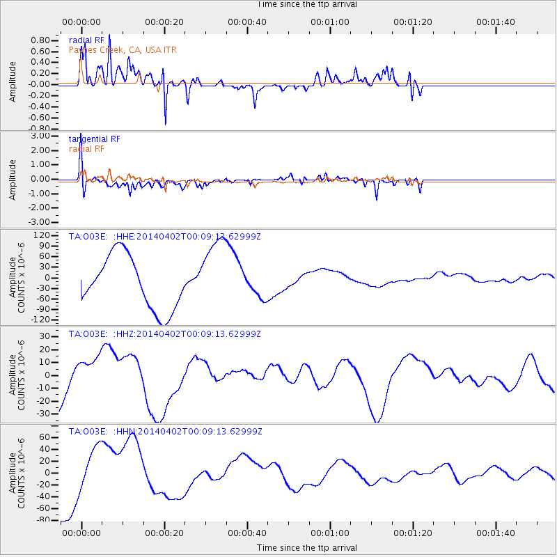
O03E Paynes Creek, CA, USA - Earthquake Result Viewer
*The percent match for this event was below the threshold and hence no stack was calculated.
| Earthquake location: |
Near Coast Of Northern Chile |
| Earthquake latitude/longitude: |
-19.9/-70.9 |
| Earthquake time(UTC): |
2014/04/01 (091) 23:57:57 GMT |
| Earthquake Depth: |
20 km |
| Earthquake Magnitude: |
6.9 MWW, 6.9 MWC |
| Earthquake Catalog/Contributor: |
NEIC PDE/NEIC COMCAT |
|
| Network: |
TA USArray Transportable Network (new EarthScope stations) |
| Station: |
O03E Paynes Creek, CA, USA |
| Lat/Lon: |
40.29 N/121.80 W |
| Elevation: |
967 m |
|
| Distance: |
76.3 deg |
| Az: |
322.362 deg |
| Baz: |
131.296 deg |
| Ray Param: |
$rayparam |
*The percent match for this event was below the threshold and hence was not used in the summary stack. |
|
| Radial Match: |
82.779015 % |
| Radial Bump: |
289 |
| Transverse Match: |
72.870636 % |
| Transverse Bump: |
400 |
| SOD ConfigId: |
626651 |
| Insert Time: |
2014-04-21 20:19:30.888 +0000 |
| GWidth: |
2.5 |
| Max Bumps: |
400 |
| Tol: |
0.001 |
|
Signal To Noise
| Channel | StoN | STA | LTA |
| TA:O03E: :HHZ:20140402T00:09:13.62999Z | 0.9238627 | 1.5883883E-5 | 1.7192904E-5 |
| TA:O03E: :HHN:20140402T00:09:13.62999Z | 0.5206042 | 3.6014946E-5 | 6.9179136E-5 |
| TA:O03E: :HHE:20140402T00:09:13.62999Z | 1.4385947 | 1.0756049E-4 | 7.476775E-5 |
| Arrivals |
| Ps | |
| PpPs | |
| PsPs/PpSs | |


