You are here: Home > Network List > UW - Pacific Northwest Regional Seismic Network Stations List
> Station MRBL Marblemount, WA, USA > Earthquake Result Viewer
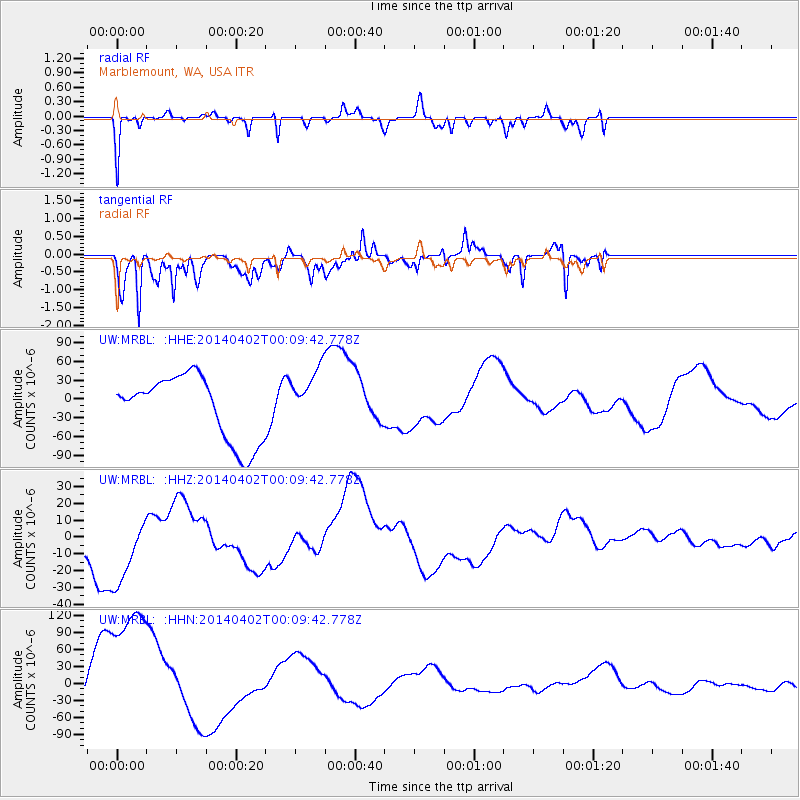
MRBL Marblemount, WA, USA - Earthquake Result Viewer
*The percent match for this event was below the threshold and hence no stack was calculated.
| Earthquake location: |
Near Coast Of Northern Chile |
| Earthquake latitude/longitude: |
-19.9/-70.9 |
| Earthquake time(UTC): |
2014/04/01 (091) 23:57:57 GMT |
| Earthquake Depth: |
20 km |
| Earthquake Magnitude: |
6.9 MWW, 6.9 MWC |
| Earthquake Catalog/Contributor: |
NEIC PDE/NEIC COMCAT |
|
| Network: |
UW Pacific Northwest Regional Seismic Network |
| Station: |
MRBL Marblemount, WA, USA |
| Lat/Lon: |
48.52 N/121.48 W |
| Elevation: |
75 m |
|
| Distance: |
81.7 deg |
| Az: |
328.739 deg |
| Baz: |
132.736 deg |
| Ray Param: |
$rayparam |
*The percent match for this event was below the threshold and hence was not used in the summary stack. |
|
| Radial Match: |
76.849724 % |
| Radial Bump: |
214 |
| Transverse Match: |
59.50418 % |
| Transverse Bump: |
400 |
| SOD ConfigId: |
626651 |
| Insert Time: |
2014-04-21 20:33:51.439 +0000 |
| GWidth: |
2.5 |
| Max Bumps: |
400 |
| Tol: |
0.001 |
|
Signal To Noise
| Channel | StoN | STA | LTA |
| UW:MRBL: :HHZ:20140402T00:09:42.778Z | 1.6276944 | 2.3061277E-5 | 1.4168063E-5 |
| UW:MRBL: :HHN:20140402T00:09:42.778Z | 1.5777583 | 1.3287448E-4 | 8.421727E-5 |
| UW:MRBL: :HHE:20140402T00:09:42.778Z | 0.866232 | 4.464348E-5 | 5.1537554E-5 |
| Arrivals |
| Ps | |
| PpPs | |
| PsPs/PpSs | |


