You are here: Home > Network List > AZ - ANZA Regional Network Stations List
> Station SMER AZ.SMER > Earthquake Result Viewer
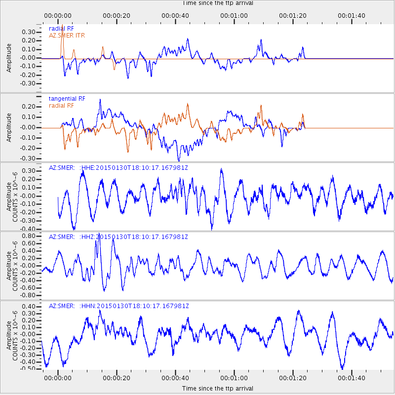
SMER AZ.SMER - Earthquake Result Viewer
*The percent match for this event was below the threshold and hence no stack was calculated.
| Earthquake location: |
Southeast Of Loyalty Islands |
| Earthquake latitude/longitude: |
-21.2/170.2 |
| Earthquake time(UTC): |
2015/01/30 (030) 17:57:57 GMT |
| Earthquake Depth: |
15 km |
| Earthquake Magnitude: |
6.0 MO |
| Earthquake Catalog/Contributor: |
NEIC PDE/NEIC ALERT |
|
| Network: |
AZ ANZA Regional Network |
| Station: |
SMER AZ.SMER |
| Lat/Lon: |
33.46 N/117.17 W |
| Elevation: |
355 m |
|
| Distance: |
88.0 deg |
| Az: |
52.989 deg |
| Baz: |
243.005 deg |
| Ray Param: |
$rayparam |
*The percent match for this event was below the threshold and hence was not used in the summary stack. |
|
| Radial Match: |
64.23762 % |
| Radial Bump: |
400 |
| Transverse Match: |
44.25225 % |
| Transverse Bump: |
400 |
| SOD ConfigId: |
3390531 |
| Insert Time: |
2019-04-16 05:44:21.349 +0000 |
| GWidth: |
2.5 |
| Max Bumps: |
400 |
| Tol: |
0.001 |
|
Signal To Noise
| Channel | StoN | STA | LTA |
| AZ:SMER: :HHZ:20150130T18:10:17.167981Z | 1.5934223 | 2.3553827E-7 | 1.4781911E-7 |
| AZ:SMER: :HHN:20150130T18:10:17.167981Z | 1.9931357 | 3.84152E-7 | 1.927375E-7 |
| AZ:SMER: :HHE:20150130T18:10:17.167981Z | 0.7102449 | 1.236487E-7 | 1.7409306E-7 |
| Arrivals |
| Ps | |
| PpPs | |
| PsPs/PpSs | |


