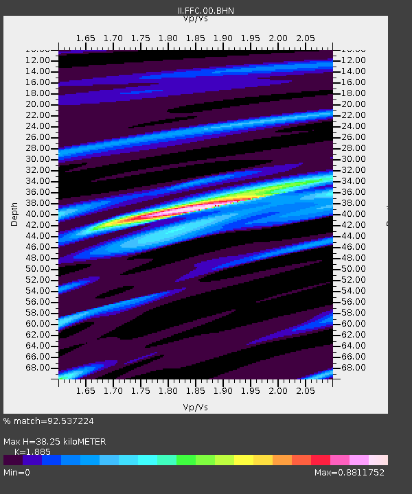
FFC Flin Flon, Canada - Earthquake Result Viewer
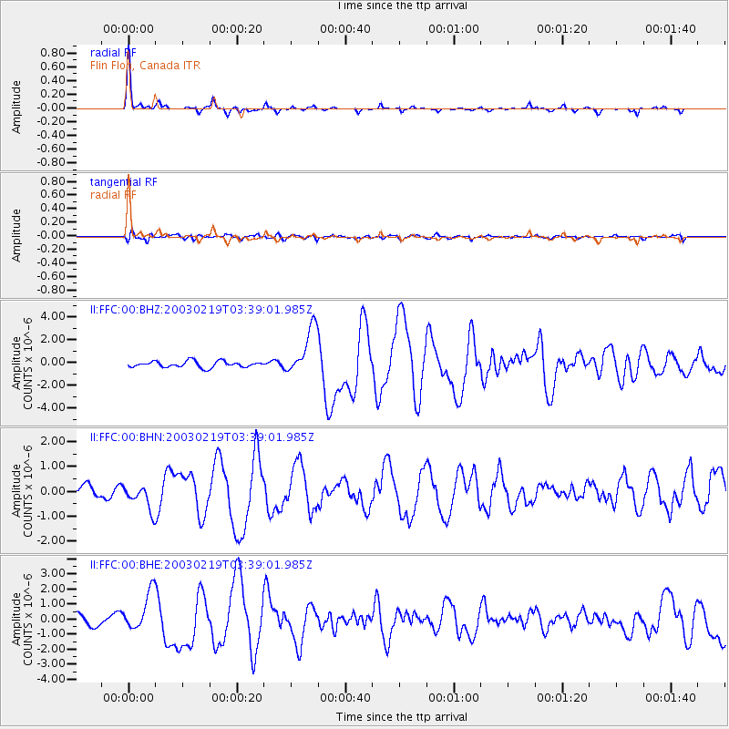
Earthquake location: Unimak Island Region, Alaska
Earthquake latitude/longitude: 53.6/-164.6
Earthquake time(UTC): 2003/02/19 (050) 03:32:36 GMT
Earthquake Depth: 19 km
Earthquake Magnitude: 5.8 MB, 6.6 MS, 6.6 MW, 6.6 MW
Earthquake Catalog/Contributor: WHDF/NEIC
Network: II Global Seismograph Network (GSN - IRIS/IDA)
Station: FFC Flin Flon, Canada
Lat/Lon: 54.72 N/101.98 W
Elevation: 338 m
Distance: 35.6 deg
Az: 62.265 deg
Baz: 294.711 deg
Ray Param: 0.077111386
Estimated Moho Depth: 38.25 km
Estimated Crust Vp/Vs: 1.88
Assumed Crust Vp: 6.552 km/s
Estimated Crust Vs: 3.476 km/s
Estimated Crust Poisson's Ratio: 0.30
Radial Match: 92.537224 %
Radial Bump: 205
Transverse Match: 68.00122 %
Transverse Bump: 400
SOD ConfigId: 4714
Insert Time: 2010-03-01 19:57:13.268 +0000
GWidth: 2.5
Max Bumps: 400
Tol: 0.001

Signal To Noise

ChannelStoNSTALTA
II:FFC:00:BHN:20030219T03:39:01.985Z1.80781015.083769E-72.8121147E-7
II:FFC:00:BHE:20030219T03:39:01.985Z3.64432741.2854517E-63.5272674E-7
II:FFC:00:BHZ:20030219T03:39:01.985Z7.91659552.141235E-62.7047423E-7
Arrivals
Ps5.6 SECOND
PpPs16 SECOND
PsPs/PpSs21 SECOND