You are here: Home > Network List > TA - USArray Transportable Network (new EarthScope stations) Stations List
> Station H17A Grant Village (NPS), Yellowstone Nt. Park, WY, USA > Earthquake Result Viewer
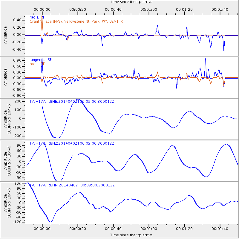
H17A Grant Village (NPS), Yellowstone Nt. Park, WY, USA - Earthquake Result Viewer
*The percent match for this event was below the threshold and hence no stack was calculated.
| Earthquake location: |
Near Coast Of Northern Chile |
| Earthquake latitude/longitude: |
-19.4/-70.3 |
| Earthquake time(UTC): |
2014/04/01 (091) 23:58:00 GMT |
| Earthquake Depth: |
18 km |
| Earthquake Magnitude: |
6.2 M |
| Earthquake Catalog/Contributor: |
NEIC PDE/NEIC ALERT |
|
| Network: |
TA USArray Transportable Network (new EarthScope stations) |
| Station: |
H17A Grant Village (NPS), Yellowstone Nt. Park, WY, USA |
| Lat/Lon: |
44.40 N/110.58 W |
| Elevation: |
2400 m |
|
| Distance: |
73.4 deg |
| Az: |
331.059 deg |
| Baz: |
140.426 deg |
| Ray Param: |
$rayparam |
*The percent match for this event was below the threshold and hence was not used in the summary stack. |
|
| Radial Match: |
72.56128 % |
| Radial Bump: |
400 |
| Transverse Match: |
63.97451 % |
| Transverse Bump: |
351 |
| SOD ConfigId: |
626651 |
| Insert Time: |
2014-04-21 21:15:01.474 +0000 |
| GWidth: |
2.5 |
| Max Bumps: |
400 |
| Tol: |
0.001 |
|
Signal To Noise
| Channel | StoN | STA | LTA |
| TA:H17A: :BHZ:20140402T00:09:00.300012Z | 3.7759428 | 8.9279085E-5 | 2.3644185E-5 |
| TA:H17A: :BHN:20140402T00:09:00.300012Z | 0.7475882 | 7.641938E-5 | 1.0222123E-4 |
| TA:H17A: :BHE:20140402T00:09:00.300012Z | 0.62759346 | 1.03978484E-4 | 1.6567808E-4 |
| Arrivals |
| Ps | |
| PpPs | |
| PsPs/PpSs | |


