You are here: Home > Network List > N4 - Central and EAstern US Network Stations List
> Station U49A Red Boiling Springs, TN, USA > Earthquake Result Viewer
U49A Red Boiling Springs, TN, USA - Earthquake Result Viewer
| Earthquake location: |
Near Coast Of Northern Chile |
| Earthquake latitude/longitude: |
-19.8/-70.9 |
| Earthquake time(UTC): |
2014/04/02 (092) 00:03:12 GMT |
| Earthquake Depth: |
10 km |
| Earthquake Magnitude: |
5.8 MB |
| Earthquake Catalog/Contributor: |
NEIC PDE/NEIC COMCAT |
|
| Network: |
N4 Central and EAstern US Network |
| Station: |
U49A Red Boiling Springs, TN, USA |
| Lat/Lon: |
36.51 N/85.78 W |
| Elevation: |
234 m |
|
| Distance: |
57.8 deg |
| Az: |
345.824 deg |
| Baz: |
163.372 deg |
| Ray Param: |
0.063261986 |
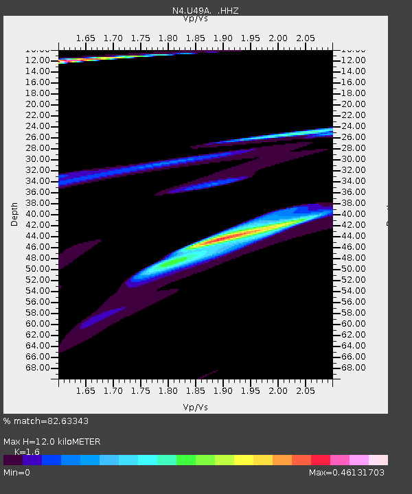
| Estimated Moho Depth: |
12.0 km |
| Estimated Crust Vp/Vs: |
1.60 |
| Assumed Crust Vp: |
6.476 km/s |
| Estimated Crust Vs: |
4.047 km/s |
| Estimated Crust Poisson's Ratio: |
0.18 |
|
| Radial Match: |
82.63343 % |
| Radial Bump: |
261 |
| Transverse Match: |
66.62419 % |
| Transverse Bump: |
208 |
| SOD ConfigId: |
626651 |
| Insert Time: |
2014-04-21 22:00:21.728 +0000 |
| GWidth: |
2.5 |
| Max Bumps: |
400 |
| Tol: |
0.001 |
|

Signal To Noise
| Channel | StoN | STA | LTA |
| N4:U49A: :HHZ:20140402T00:12:32.29001Z | 0.5169147 | 1.6172842E-5 | 3.128725E-5 |
| N4:U49A: :HHN:20140402T00:12:32.29001Z | 1.8705434 | 5.612817E-5 | 3.0006346E-5 |
| N4:U49A: :HHE:20140402T00:12:32.29001Z | 1.7132871 | 1.2633731E-4 | 7.373972E-5 |
| Arrivals |
| Ps | 1.2 SECOND |
| PpPs | 4.6 SECOND |
| PsPs/PpSs | 5.7 SECOND |


