You are here: Home > Network List > CI - Caltech Regional Seismic Network Stations List
> Station MPM Manuel Prospect Mine, California, USA > Earthquake Result Viewer
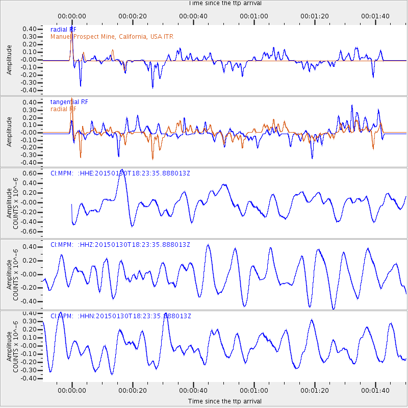
MPM Manuel Prospect Mine, California, USA - Earthquake Result Viewer
*The percent match for this event was below the threshold and hence no stack was calculated.
| Earthquake location: |
Southeast Of Loyalty Islands |
| Earthquake latitude/longitude: |
-21.4/170.2 |
| Earthquake time(UTC): |
2015/01/30 (030) 18:11:12 GMT |
| Earthquake Depth: |
10 km |
| Earthquake Magnitude: |
5.0 MW, 5.1 mb |
| Earthquake Catalog/Contributor: |
ISC/ISC |
|
| Network: |
CI Caltech Regional Seismic Network |
| Station: |
MPM Manuel Prospect Mine, California, USA |
| Lat/Lon: |
36.06 N/117.49 W |
| Elevation: |
185 m |
|
| Distance: |
89.0 deg |
| Az: |
50.56 deg |
| Baz: |
242.67 deg |
| Ray Param: |
$rayparam |
*The percent match for this event was below the threshold and hence was not used in the summary stack. |
|
| Radial Match: |
40.93885 % |
| Radial Bump: |
263 |
| Transverse Match: |
40.08316 % |
| Transverse Bump: |
400 |
| SOD ConfigId: |
3390531 |
| Insert Time: |
2019-04-16 05:51:10.808 +0000 |
| GWidth: |
2.5 |
| Max Bumps: |
400 |
| Tol: |
0.001 |
|
Signal To Noise
| Channel | StoN | STA | LTA |
| CI:MPM: :HHZ:20150130T18:23:35.888013Z | 0.68538785 | 8.24269E-8 | 1.2026315E-7 |
| CI:MPM: :HHN:20150130T18:23:35.888013Z | 0.46242857 | 9.604545E-8 | 2.0769791E-7 |
| CI:MPM: :HHE:20150130T18:23:35.888013Z | 0.610764 | 1.6862258E-7 | 2.7608465E-7 |
| Arrivals |
| Ps | |
| PpPs | |
| PsPs/PpSs | |


