You are here: Home > Network List > TA - USArray Transportable Network (new EarthScope stations) Stations List
> Station H17A Grant Village (NPS), Yellowstone Nt. Park, WY, USA > Earthquake Result Viewer
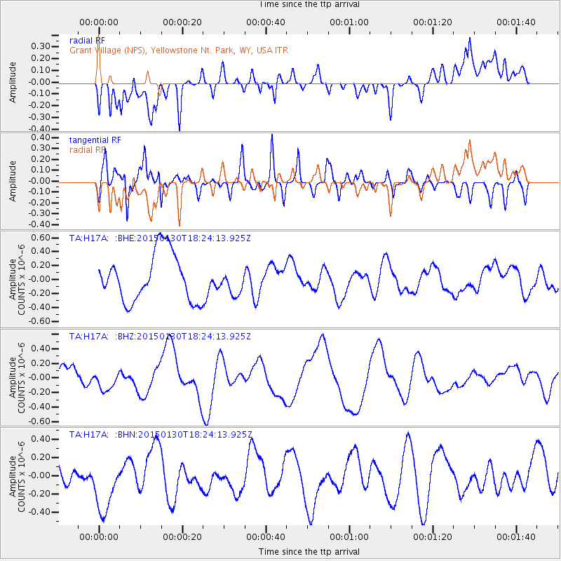
H17A Grant Village (NPS), Yellowstone Nt. Park, WY, USA - Earthquake Result Viewer
*The percent match for this event was below the threshold and hence no stack was calculated.
| Earthquake location: |
Southeast Of Loyalty Islands |
| Earthquake latitude/longitude: |
-21.4/170.2 |
| Earthquake time(UTC): |
2015/01/30 (030) 18:11:12 GMT |
| Earthquake Depth: |
10 km |
| Earthquake Magnitude: |
5.0 MW, 5.1 mb |
| Earthquake Catalog/Contributor: |
ISC/ISC |
|
| Network: |
TA USArray Transportable Network (new EarthScope stations) |
| Station: |
H17A Grant Village (NPS), Yellowstone Nt. Park, WY, USA |
| Lat/Lon: |
44.40 N/110.58 W |
| Elevation: |
2400 m |
|
| Distance: |
97.4 deg |
| Az: |
45.251 deg |
| Baz: |
247.43 deg |
| Ray Param: |
$rayparam |
*The percent match for this event was below the threshold and hence was not used in the summary stack. |
|
| Radial Match: |
36.54121 % |
| Radial Bump: |
400 |
| Transverse Match: |
64.13787 % |
| Transverse Bump: |
400 |
| SOD ConfigId: |
3390531 |
| Insert Time: |
2019-04-16 05:53:07.077 +0000 |
| GWidth: |
2.5 |
| Max Bumps: |
400 |
| Tol: |
0.001 |
|
Signal To Noise
| Channel | StoN | STA | LTA |
| TA:H17A: :BHZ:20150130T18:24:13.925Z | 0.8228919 | 1.3680908E-7 | 1.6625403E-7 |
| TA:H17A: :BHN:20150130T18:24:13.925Z | 2.2880096 | 3.221179E-7 | 1.4078519E-7 |
| TA:H17A: :BHE:20150130T18:24:13.925Z | 0.52809626 | 1.803082E-7 | 3.4143056E-7 |
| Arrivals |
| Ps | |
| PpPs | |
| PsPs/PpSs | |


