You are here: Home > Network List > TA - USArray Transportable Network (new EarthScope stations) Stations List
> Station L04D Klamath Falls, OR, USA > Earthquake Result Viewer
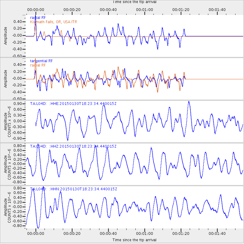
L04D Klamath Falls, OR, USA - Earthquake Result Viewer
*The percent match for this event was below the threshold and hence no stack was calculated.
| Earthquake location: |
Southeast Of Loyalty Islands |
| Earthquake latitude/longitude: |
-21.4/170.2 |
| Earthquake time(UTC): |
2015/01/30 (030) 18:11:12 GMT |
| Earthquake Depth: |
10 km |
| Earthquake Magnitude: |
5.0 MW, 5.1 mb |
| Earthquake Catalog/Contributor: |
ISC/ISC |
|
| Network: |
TA USArray Transportable Network (new EarthScope stations) |
| Station: |
L04D Klamath Falls, OR, USA |
| Lat/Lon: |
42.22 N/122.30 W |
| Elevation: |
1437 m |
|
| Distance: |
88.7 deg |
| Az: |
43.366 deg |
| Baz: |
239.498 deg |
| Ray Param: |
$rayparam |
*The percent match for this event was below the threshold and hence was not used in the summary stack. |
|
| Radial Match: |
57.92391 % |
| Radial Bump: |
400 |
| Transverse Match: |
63.306187 % |
| Transverse Bump: |
348 |
| SOD ConfigId: |
3390531 |
| Insert Time: |
2019-04-16 05:53:08.857 +0000 |
| GWidth: |
2.5 |
| Max Bumps: |
400 |
| Tol: |
0.001 |
|
Signal To Noise
| Channel | StoN | STA | LTA |
| TA:L04D: :HHZ:20150130T18:23:34.440015Z | 1.6973685 | 5.5209824E-7 | 3.2526717E-7 |
| TA:L04D: :HHN:20150130T18:23:34.440015Z | 1.7316016 | 6.3093785E-7 | 3.6436663E-7 |
| TA:L04D: :HHE:20150130T18:23:34.440015Z | 1.0069939 | 3.4679593E-7 | 3.4438733E-7 |
| Arrivals |
| Ps | |
| PpPs | |
| PsPs/PpSs | |


