You are here: Home > Network List > TA - USArray Transportable Network (new EarthScope stations) Stations List
> Station J01E Myrtle Point, OR, USA > Earthquake Result Viewer
J01E Myrtle Point, OR, USA - Earthquake Result Viewer
| Earthquake location: |
Near Coast Of Northern Chile |
| Earthquake latitude/longitude: |
-19.8/-70.9 |
| Earthquake time(UTC): |
2014/04/02 (092) 00:03:12 GMT |
| Earthquake Depth: |
10 km |
| Earthquake Magnitude: |
5.8 MB |
| Earthquake Catalog/Contributor: |
NEIC PDE/NEIC COMCAT |
|
| Network: |
TA USArray Transportable Network (new EarthScope stations) |
| Station: |
J01E Myrtle Point, OR, USA |
| Lat/Lon: |
43.16 N/123.93 W |
| Elevation: |
128 m |
|
| Distance: |
79.4 deg |
| Az: |
323.49 deg |
| Baz: |
130.056 deg |
| Ray Param: |
0.048986647 |
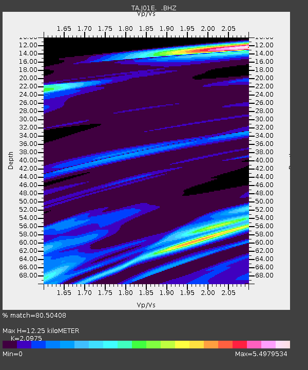
| Estimated Moho Depth: |
12.25 km |
| Estimated Crust Vp/Vs: |
2.10 |
| Assumed Crust Vp: |
6.522 km/s |
| Estimated Crust Vs: |
3.109 km/s |
| Estimated Crust Poisson's Ratio: |
0.35 |
|
| Radial Match: |
80.50408 % |
| Radial Bump: |
400 |
| Transverse Match: |
45.657887 % |
| Transverse Bump: |
348 |
| SOD ConfigId: |
626651 |
| Insert Time: |
2014-04-21 22:12:43.183 +0000 |
| GWidth: |
2.5 |
| Max Bumps: |
400 |
| Tol: |
0.001 |
|
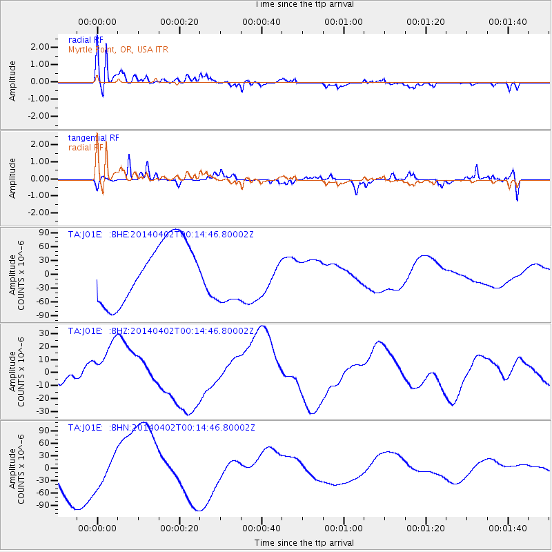
Signal To Noise
| Channel | StoN | STA | LTA |
| TA:J01E: :BHZ:20140402T00:14:46.80002Z | 2.5197244 | 2.1230037E-5 | 8.425539E-6 |
| TA:J01E: :BHN:20140402T00:14:46.80002Z | 0.7423781 | 3.623628E-5 | 4.881108E-5 |
| TA:J01E: :BHE:20140402T00:14:46.80002Z | 1.0398322 | 6.697759E-5 | 6.441191E-5 |
| Arrivals |
| Ps | 2.1 SECOND |
| PpPs | 5.7 SECOND |
| PsPs/PpSs | 7.8 SECOND |


