You are here: Home > Network List > TA - USArray Transportable Network (new EarthScope stations) Stations List
> Station P48A Milroy, IN, USA > Earthquake Result Viewer
P48A Milroy, IN, USA - Earthquake Result Viewer
| Earthquake location: |
Near Coast Of Northern Chile |
| Earthquake latitude/longitude: |
-19.8/-70.9 |
| Earthquake time(UTC): |
2014/04/02 (092) 00:03:12 GMT |
| Earthquake Depth: |
10 km |
| Earthquake Magnitude: |
5.8 MB |
| Earthquake Catalog/Contributor: |
NEIC PDE/NEIC COMCAT |
|
| Network: |
TA USArray Transportable Network (new EarthScope stations) |
| Station: |
P48A Milroy, IN, USA |
| Lat/Lon: |
39.46 N/85.43 W |
| Elevation: |
300 m |
|
| Distance: |
60.5 deg |
| Az: |
347.092 deg |
| Baz: |
164.239 deg |
| Ray Param: |
0.06146158 |
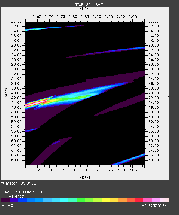
| Estimated Moho Depth: |
44.0 km |
| Estimated Crust Vp/Vs: |
1.64 |
| Assumed Crust Vp: |
6.498 km/s |
| Estimated Crust Vs: |
3.956 km/s |
| Estimated Crust Poisson's Ratio: |
0.21 |
|
| Radial Match: |
85.8968 % |
| Radial Bump: |
326 |
| Transverse Match: |
59.522335 % |
| Transverse Bump: |
334 |
| SOD ConfigId: |
626651 |
| Insert Time: |
2014-04-21 22:18:40.788 +0000 |
| GWidth: |
2.5 |
| Max Bumps: |
400 |
| Tol: |
0.001 |
|

Signal To Noise
| Channel | StoN | STA | LTA |
| TA:P48A: :BHZ:20140402T00:12:51.30002Z | 0.4078327 | 2.5238884E-5 | 6.188539E-5 |
| TA:P48A: :BHN:20140402T00:12:51.30002Z | 1.5879387 | 7.9154306E-5 | 4.9847204E-5 |
| TA:P48A: :BHE:20140402T00:12:51.30002Z | 3.7361505 | 7.5741984E-5 | 2.0272733E-5 |
| Arrivals |
| Ps | 4.6 SECOND |
| PpPs | 17 SECOND |
| PsPs/PpSs | 22 SECOND |


