You are here: Home > Network List > TA - USArray Transportable Network (new EarthScope stations) Stations List
> Station P50A Jamestown, OH, USA > Earthquake Result Viewer
P50A Jamestown, OH, USA - Earthquake Result Viewer
| Earthquake location: |
Near Coast Of Northern Chile |
| Earthquake latitude/longitude: |
-19.8/-70.9 |
| Earthquake time(UTC): |
2014/04/02 (092) 00:03:12 GMT |
| Earthquake Depth: |
10 km |
| Earthquake Magnitude: |
5.8 MB |
| Earthquake Catalog/Contributor: |
NEIC PDE/NEIC COMCAT |
|
| Network: |
TA USArray Transportable Network (new EarthScope stations) |
| Station: |
P50A Jamestown, OH, USA |
| Lat/Lon: |
39.61 N/83.80 W |
| Elevation: |
318 m |
|
| Distance: |
60.4 deg |
| Az: |
348.533 deg |
| Baz: |
165.981 deg |
| Ray Param: |
0.061580855 |
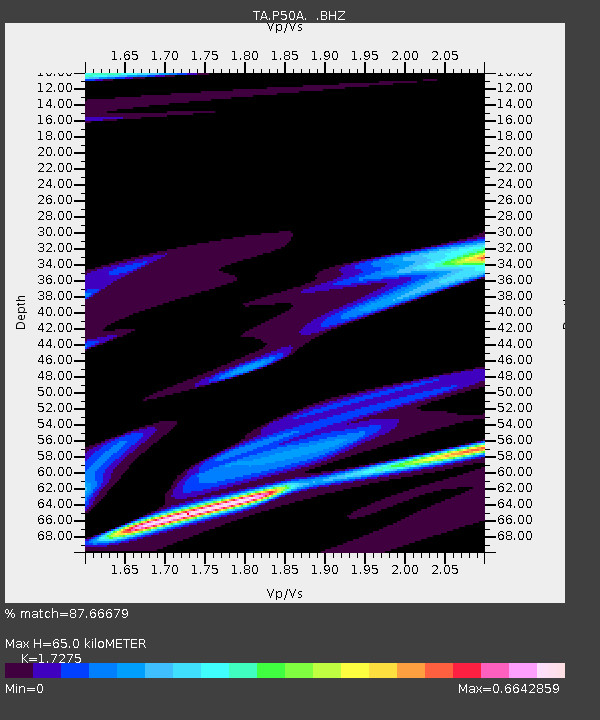
| Estimated Moho Depth: |
65.0 km |
| Estimated Crust Vp/Vs: |
1.73 |
| Assumed Crust Vp: |
6.232 km/s |
| Estimated Crust Vs: |
3.607 km/s |
| Estimated Crust Poisson's Ratio: |
0.25 |
|
| Radial Match: |
87.66679 % |
| Radial Bump: |
384 |
| Transverse Match: |
69.47611 % |
| Transverse Bump: |
400 |
| SOD ConfigId: |
626651 |
| Insert Time: |
2014-04-21 22:18:45.215 +0000 |
| GWidth: |
2.5 |
| Max Bumps: |
400 |
| Tol: |
0.001 |
|

Signal To Noise
| Channel | StoN | STA | LTA |
| TA:P50A: :BHZ:20140402T00:12:50.074006Z | 0.42277536 | 2.3794913E-5 | 5.628264E-5 |
| TA:P50A: :BHN:20140402T00:12:50.074006Z | 1.2509348 | 3.447046E-5 | 2.7555763E-5 |
| TA:P50A: :BHE:20140402T00:12:50.074006Z | 3.588556 | 8.208602E-5 | 2.2874388E-5 |
| Arrivals |
| Ps | 7.9 SECOND |
| PpPs | 27 SECOND |
| PsPs/PpSs | 35 SECOND |


