You are here: Home > Network List > TA - USArray Transportable Network (new EarthScope stations) Stations List
> Station Q48A North Vernon, IN, USA > Earthquake Result Viewer
Q48A North Vernon, IN, USA - Earthquake Result Viewer
| Earthquake location: |
Near Coast Of Northern Chile |
| Earthquake latitude/longitude: |
-19.8/-70.9 |
| Earthquake time(UTC): |
2014/04/02 (092) 00:03:12 GMT |
| Earthquake Depth: |
10 km |
| Earthquake Magnitude: |
5.8 MB |
| Earthquake Catalog/Contributor: |
NEIC PDE/NEIC COMCAT |
|
| Network: |
TA USArray Transportable Network (new EarthScope stations) |
| Station: |
Q48A North Vernon, IN, USA |
| Lat/Lon: |
38.93 N/85.73 W |
| Elevation: |
185 m |
|
| Distance: |
60.1 deg |
| Az: |
346.662 deg |
| Baz: |
163.834 deg |
| Ray Param: |
0.061754525 |
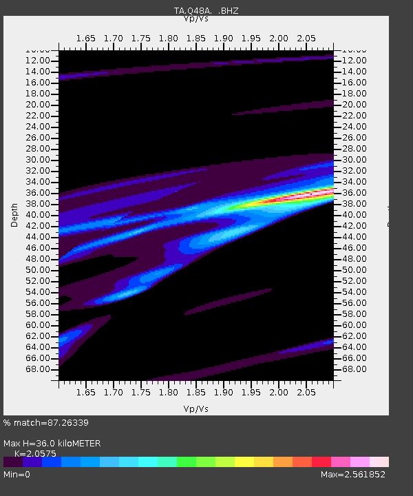
| Estimated Moho Depth: |
36.0 km |
| Estimated Crust Vp/Vs: |
2.06 |
| Assumed Crust Vp: |
6.498 km/s |
| Estimated Crust Vs: |
3.158 km/s |
| Estimated Crust Poisson's Ratio: |
0.35 |
|
| Radial Match: |
87.26339 % |
| Radial Bump: |
400 |
| Transverse Match: |
73.01306 % |
| Transverse Bump: |
211 |
| SOD ConfigId: |
626651 |
| Insert Time: |
2014-04-21 22:19:19.183 +0000 |
| GWidth: |
2.5 |
| Max Bumps: |
400 |
| Tol: |
0.001 |
|
Signal To Noise
| Channel | StoN | STA | LTA |
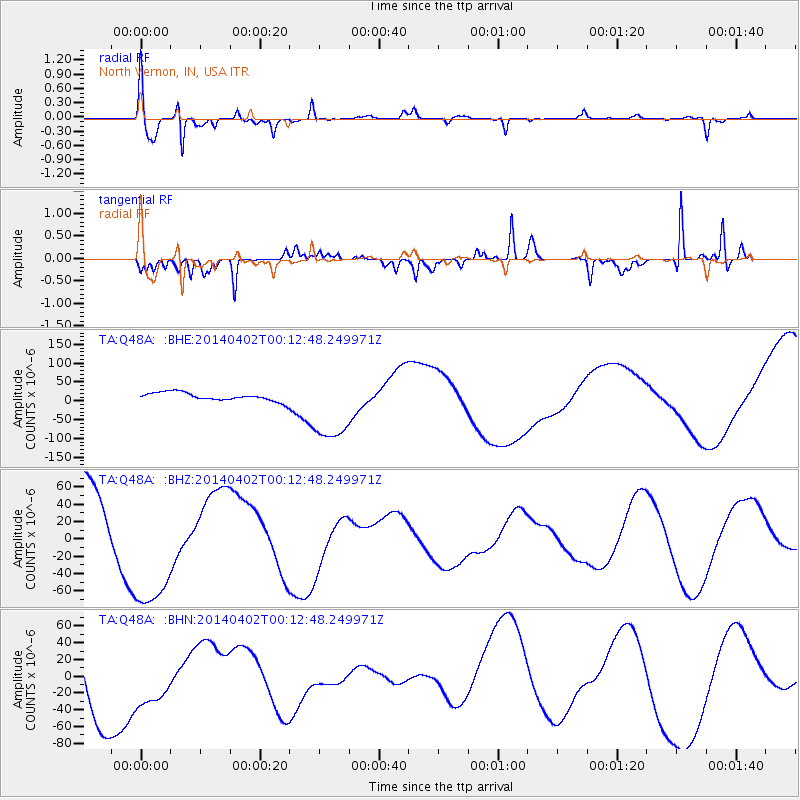
| TA:Q48A: :BHZ:20140402T00:12:48.249971Z | 1.5931474 | 7.44031E-5 | 4.6701956E-5 |
| TA:Q48A: :BHN:20140402T00:12:48.249971Z | 0.5691669 | 3.088982E-5 | 5.4271986E-5 |
| TA:Q48A: :BHE:20140402T00:12:48.249971Z | 8.924393 | 9.8138764E-5 | 1.0996689E-5 |
| Arrivals |
| Ps | 6.1 SECOND |
| PpPs | 16 SECOND |
| PsPs/PpSs | 22 SECOND |


