You are here: Home > Network List > TA - USArray Transportable Network (new EarthScope stations) Stations List
> Station Q54A Coxs Mills, WV, USA > Earthquake Result Viewer
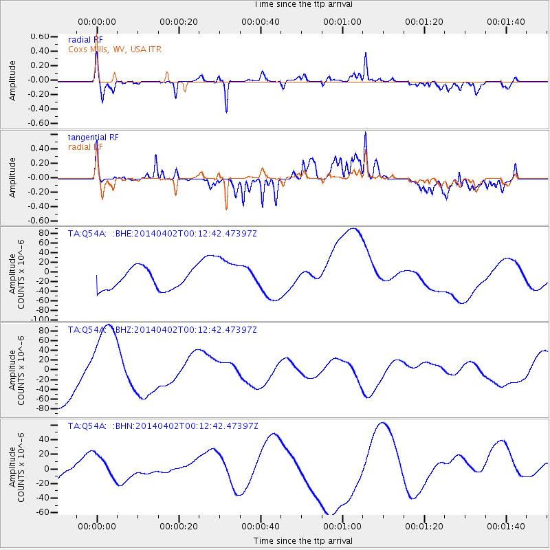
Q54A Coxs Mills, WV, USA - Earthquake Result Viewer
*The percent match for this event was below the threshold and hence no stack was calculated.
| Earthquake location: |
Near Coast Of Northern Chile |
| Earthquake latitude/longitude: |
-19.8/-70.9 |
| Earthquake time(UTC): |
2014/04/02 (092) 00:03:12 GMT |
| Earthquake Depth: |
10 km |
| Earthquake Magnitude: |
5.8 MB |
| Earthquake Catalog/Contributor: |
NEIC PDE/NEIC COMCAT |
|
| Network: |
TA USArray Transportable Network (new EarthScope stations) |
| Station: |
Q54A Coxs Mills, WV, USA |
| Lat/Lon: |
38.98 N/80.83 W |
| Elevation: |
254 m |
|
| Distance: |
59.3 deg |
| Az: |
350.976 deg |
| Baz: |
169.08 deg |
| Ray Param: |
$rayparam |
*The percent match for this event was below the threshold and hence was not used in the summary stack. |
|
| Radial Match: |
72.519485 % |
| Radial Bump: |
400 |
| Transverse Match: |
57.696503 % |
| Transverse Bump: |
249 |
| SOD ConfigId: |
626651 |
| Insert Time: |
2014-04-21 22:19:42.417 +0000 |
| GWidth: |
2.5 |
| Max Bumps: |
400 |
| Tol: |
0.001 |
|
Signal To Noise
| Channel | StoN | STA | LTA |
| TA:Q54A: :BHZ:20140402T00:12:42.47397Z | 1.8306721 | 8.3743966E-5 | 4.5744928E-5 |
| TA:Q54A: :BHN:20140402T00:12:42.47397Z | 0.75275844 | 1.9308403E-5 | 2.5650197E-5 |
| TA:Q54A: :BHE:20140402T00:12:42.47397Z | 1.878347 | 3.951141E-5 | 2.1035203E-5 |
| Arrivals |
| Ps | |
| PpPs | |
| PsPs/PpSs | |


