You are here: Home > Network List > TA - USArray Transportable Network (new EarthScope stations) Stations List
> Station R49A Shelbyville, KY, USA > Earthquake Result Viewer
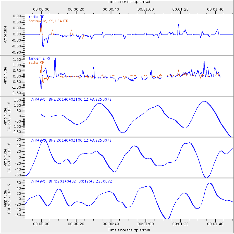
R49A Shelbyville, KY, USA - Earthquake Result Viewer
*The percent match for this event was below the threshold and hence no stack was calculated.
| Earthquake location: |
Near Coast Of Northern Chile |
| Earthquake latitude/longitude: |
-19.8/-70.9 |
| Earthquake time(UTC): |
2014/04/02 (092) 00:03:12 GMT |
| Earthquake Depth: |
10 km |
| Earthquake Magnitude: |
5.8 MB |
| Earthquake Catalog/Contributor: |
NEIC PDE/NEIC COMCAT |
|
| Network: |
TA USArray Transportable Network (new EarthScope stations) |
| Station: |
R49A Shelbyville, KY, USA |
| Lat/Lon: |
38.29 N/85.17 W |
| Elevation: |
251 m |
|
| Distance: |
59.4 deg |
| Az: |
346.948 deg |
| Baz: |
164.326 deg |
| Ray Param: |
$rayparam |
*The percent match for this event was below the threshold and hence was not used in the summary stack. |
|
| Radial Match: |
53.893856 % |
| Radial Bump: |
400 |
| Transverse Match: |
68.62612 % |
| Transverse Bump: |
400 |
| SOD ConfigId: |
626651 |
| Insert Time: |
2014-04-21 22:20:18.041 +0000 |
| GWidth: |
2.5 |
| Max Bumps: |
400 |
| Tol: |
0.001 |
|
Signal To Noise
| Channel | StoN | STA | LTA |
| TA:R49A: :BHZ:20140402T00:12:43.225007Z | 1.5331851 | 5.5692715E-5 | 3.6324847E-5 |
| TA:R49A: :BHN:20140402T00:12:43.225007Z | 1.0562073 | 1.4290152E-5 | 1.3529684E-5 |
| TA:R49A: :BHE:20140402T00:12:43.225007Z | 4.0670795 | 1.2856386E-4 | 3.1610853E-5 |
| Arrivals |
| Ps | |
| PpPs | |
| PsPs/PpSs | |


