You are here: Home > Network List > TA - USArray Transportable Network (new EarthScope stations) Stations List
> Station R55A Marlinton, WV, USA > Earthquake Result Viewer
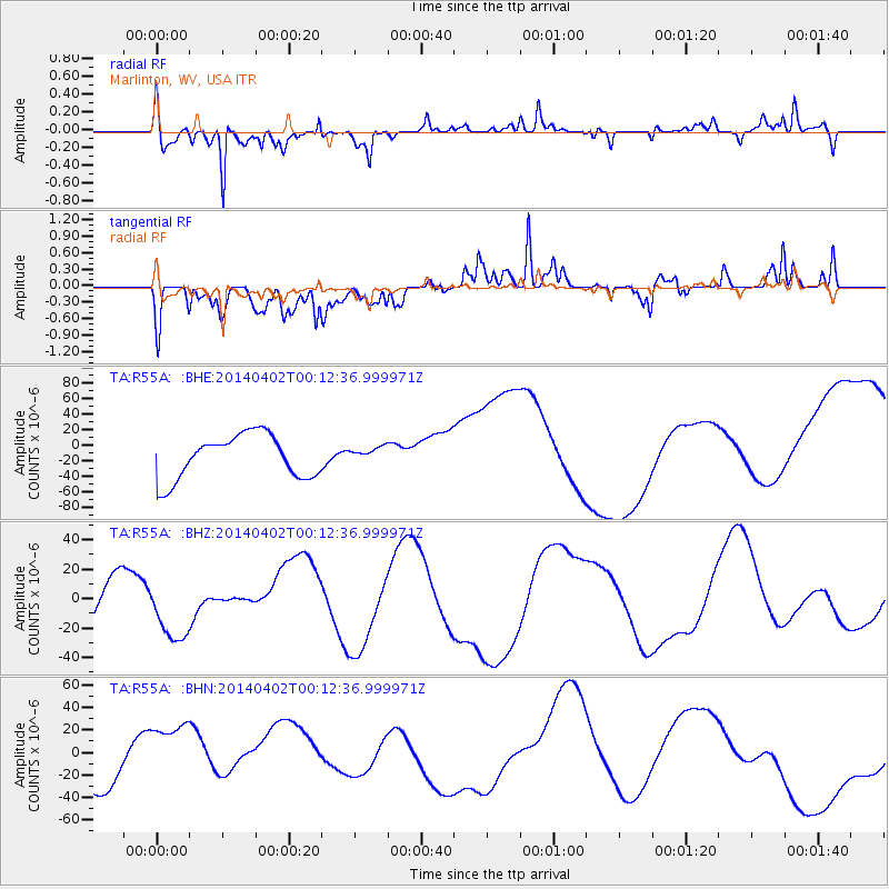
R55A Marlinton, WV, USA - Earthquake Result Viewer
*The percent match for this event was below the threshold and hence no stack was calculated.
| Earthquake location: |
Near Coast Of Northern Chile |
| Earthquake latitude/longitude: |
-19.8/-70.9 |
| Earthquake time(UTC): |
2014/04/02 (092) 00:03:12 GMT |
| Earthquake Depth: |
10 km |
| Earthquake Magnitude: |
5.8 MB |
| Earthquake Catalog/Contributor: |
NEIC PDE/NEIC COMCAT |
|
| Network: |
TA USArray Transportable Network (new EarthScope stations) |
| Station: |
R55A Marlinton, WV, USA |
| Lat/Lon: |
38.28 N/80.12 W |
| Elevation: |
833 m |
|
| Distance: |
58.5 deg |
| Az: |
351.469 deg |
| Baz: |
169.779 deg |
| Ray Param: |
$rayparam |
*The percent match for this event was below the threshold and hence was not used in the summary stack. |
|
| Radial Match: |
72.3801 % |
| Radial Bump: |
324 |
| Transverse Match: |
65.98927 % |
| Transverse Bump: |
400 |
| SOD ConfigId: |
626651 |
| Insert Time: |
2014-04-21 22:20:29.730 +0000 |
| GWidth: |
2.5 |
| Max Bumps: |
400 |
| Tol: |
0.001 |
|
Signal To Noise
| Channel | StoN | STA | LTA |
| TA:R55A: :BHZ:20140402T00:12:36.999971Z | 1.6551363 | 2.1314423E-5 | 1.2877745E-5 |
| TA:R55A: :BHN:20140402T00:12:36.999971Z | 1.2353932 | 3.2022588E-5 | 2.5920968E-5 |
| TA:R55A: :BHE:20140402T00:12:36.999971Z | 0.3328662 | 9.377433E-6 | 2.8171782E-5 |
| Arrivals |
| Ps | |
| PpPs | |
| PsPs/PpSs | |


