You are here: Home > Network List > TA - USArray Transportable Network (new EarthScope stations) Stations List
> Station Y57A Sumter, SC, USA > Earthquake Result Viewer
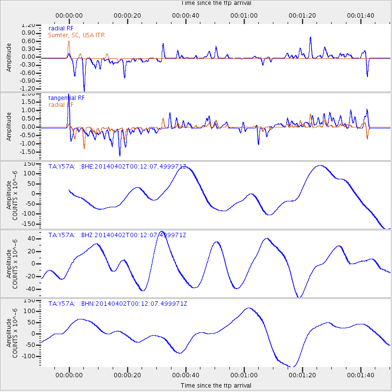
Y57A Sumter, SC, USA - Earthquake Result Viewer
*The percent match for this event was below the threshold and hence no stack was calculated.
| Earthquake location: |
Near Coast Of Northern Chile |
| Earthquake latitude/longitude: |
-19.8/-70.9 |
| Earthquake time(UTC): |
2014/04/02 (092) 00:03:12 GMT |
| Earthquake Depth: |
10 km |
| Earthquake Magnitude: |
5.8 MB |
| Earthquake Catalog/Contributor: |
NEIC PDE/NEIC COMCAT |
|
| Network: |
TA USArray Transportable Network (new EarthScope stations) |
| Station: |
Y57A Sumter, SC, USA |
| Lat/Lon: |
34.02 N/80.39 W |
| Elevation: |
56 m |
|
| Distance: |
54.3 deg |
| Az: |
350.266 deg |
| Baz: |
168.953 deg |
| Ray Param: |
$rayparam |
*The percent match for this event was below the threshold and hence was not used in the summary stack. |
|
| Radial Match: |
72.79578 % |
| Radial Bump: |
263 |
| Transverse Match: |
62.960518 % |
| Transverse Bump: |
324 |
| SOD ConfigId: |
626651 |
| Insert Time: |
2014-04-21 22:23:14.452 +0000 |
| GWidth: |
2.5 |
| Max Bumps: |
400 |
| Tol: |
0.001 |
|
Signal To Noise
| Channel | StoN | STA | LTA |
| TA:Y57A: :BHZ:20140402T00:12:07.499971Z | 0.9117906 | 1.3033138E-5 | 1.4294003E-5 |
| TA:Y57A: :BHN:20140402T00:12:07.499971Z | 3.6671805 | 7.83405E-5 | 2.1362597E-5 |
| TA:Y57A: :BHE:20140402T00:12:07.499971Z | 1.1689215 | 4.159506E-5 | 3.5584133E-5 |
| Arrivals |
| Ps | |
| PpPs | |
| PsPs/PpSs | |


