You are here: Home > Network List > TA - USArray Transportable Network (new EarthScope stations) Stations List
> Station Z41A Richland Creek Farm, El Dorado, AR, USA > Earthquake Result Viewer
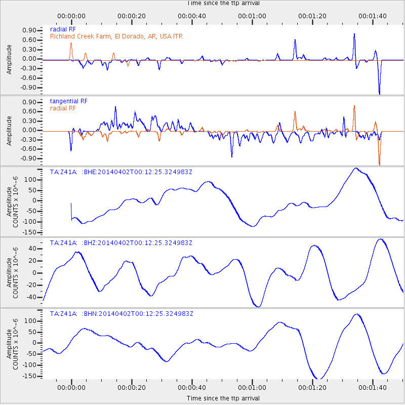
Z41A Richland Creek Farm, El Dorado, AR, USA - Earthquake Result Viewer
*The percent match for this event was below the threshold and hence no stack was calculated.
| Earthquake location: |
Near Coast Of Northern Chile |
| Earthquake latitude/longitude: |
-19.8/-70.9 |
| Earthquake time(UTC): |
2014/04/02 (092) 00:03:12 GMT |
| Earthquake Depth: |
10 km |
| Earthquake Magnitude: |
5.8 MB |
| Earthquake Catalog/Contributor: |
NEIC PDE/NEIC COMCAT |
|
| Network: |
TA USArray Transportable Network (new EarthScope stations) |
| Station: |
Z41A Richland Creek Farm, El Dorado, AR, USA |
| Lat/Lon: |
33.26 N/92.80 W |
| Elevation: |
62 m |
|
| Distance: |
56.8 deg |
| Az: |
338.041 deg |
| Baz: |
155.159 deg |
| Ray Param: |
$rayparam |
*The percent match for this event was below the threshold and hence was not used in the summary stack. |
|
| Radial Match: |
34.228138 % |
| Radial Bump: |
199 |
| Transverse Match: |
43.359173 % |
| Transverse Bump: |
400 |
| SOD ConfigId: |
626651 |
| Insert Time: |
2014-04-21 22:23:28.664 +0000 |
| GWidth: |
2.5 |
| Max Bumps: |
400 |
| Tol: |
0.001 |
|
Signal To Noise
| Channel | StoN | STA | LTA |
| TA:Z41A: :BHZ:20140402T00:12:25.324983Z | 0.9100703 | 3.183562E-5 | 3.4981495E-5 |
| TA:Z41A: :BHN:20140402T00:12:25.324983Z | 2.7332618 | 6.7177556E-5 | 2.4577797E-5 |
| TA:Z41A: :BHE:20140402T00:12:25.324983Z | 2.241837 | 9.009798E-5 | 4.0189352E-5 |
| Arrivals |
| Ps | |
| PpPs | |
| PsPs/PpSs | |


