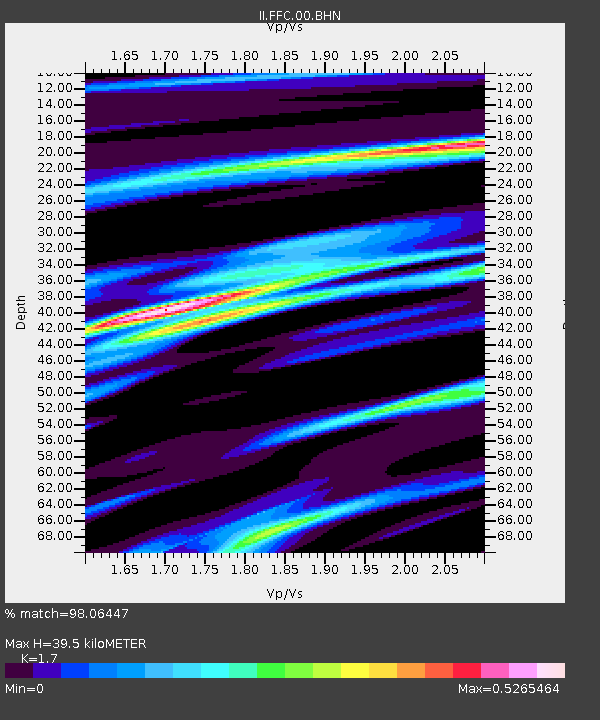
FFC Flin Flon, Canada - Earthquake Result Viewer
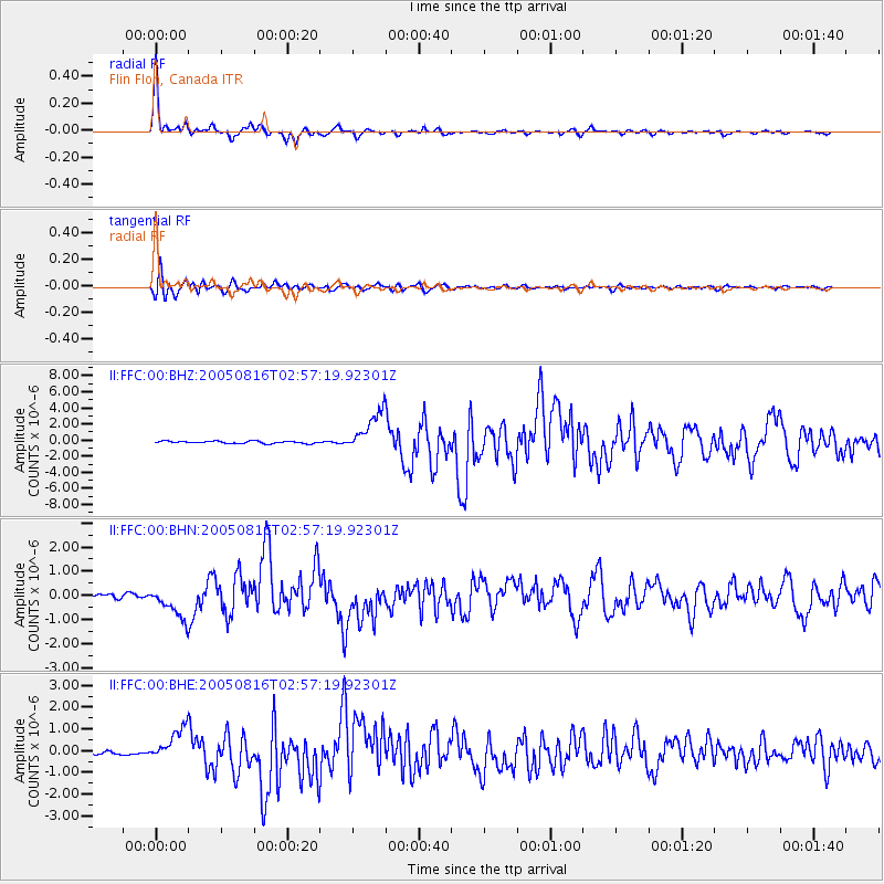
Earthquake location: Near East Coast Of Honshu, Japan
Earthquake latitude/longitude: 38.3/142.0
Earthquake time(UTC): 2005/08/16 (228) 02:46:28 GMT
Earthquake Depth: 36 km
Earthquake Magnitude: 6.5 MB, 6.8 MS, 7.2 MW, 7.1 MW
Earthquake Catalog/Contributor: WHDF/NEIC
Network: II Global Seismograph Network (GSN - IRIS/IDA)
Station: FFC Flin Flon, Canada
Lat/Lon: 54.72 N/101.98 W
Elevation: 338 m
Distance: 72.4 deg
Az: 33.167 deg
Baz: 312.075 deg
Ray Param: 0.05363332
Estimated Moho Depth: 39.5 km
Estimated Crust Vp/Vs: 1.70
Assumed Crust Vp: 6.552 km/s
Estimated Crust Vs: 3.854 km/s
Estimated Crust Poisson's Ratio: 0.24
Radial Match: 98.06447 %
Radial Bump: 249
Transverse Match: 92.015 %
Transverse Bump: 400
SOD ConfigId: 2475
Insert Time: 2010-03-01 19:59:17.797 +0000
GWidth: 2.5
Max Bumps: 400
Tol: 0.001

Signal To Noise

ChannelStoNSTALTA
II:FFC:00:BHN:20050816T02:57:19.92301Z5.504316.7086273E-71.2187954E-7
II:FFC:00:BHE:20050816T02:57:19.92301Z10.1097837.7506246E-77.66646E-8
II:FFC:00:BHZ:20050816T02:57:19.92301Z17.1344452.490259E-61.4533644E-7
Arrivals
Ps4.4 SECOND
PpPs16 SECOND
PsPs/PpSs20 SECOND