You are here: Home > Network List > TA - USArray Transportable Network (new EarthScope stations) Stations List
> Station C06D Leavenworth, WQ, USA > Earthquake Result Viewer
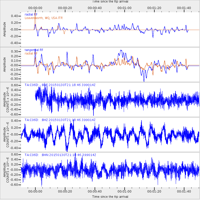
C06D Leavenworth, WQ, USA - Earthquake Result Viewer
*The percent match for this event was below the threshold and hence no stack was calculated.
| Earthquake location: |
Tonga Islands |
| Earthquake latitude/longitude: |
-15.1/-173.6 |
| Earthquake time(UTC): |
2015/01/30 (030) 21:07:17 GMT |
| Earthquake Depth: |
10 km |
| Earthquake Magnitude: |
5.3 MW, 4.9 mb, 4.2 MS |
| Earthquake Catalog/Contributor: |
ISC/ISC |
|
| Network: |
TA USArray Transportable Network (new EarthScope stations) |
| Station: |
C06D Leavenworth, WQ, USA |
| Lat/Lon: |
47.92 N/120.89 W |
| Elevation: |
544 m |
|
| Distance: |
78.3 deg |
| Az: |
33.095 deg |
| Baz: |
231.631 deg |
| Ray Param: |
$rayparam |
*The percent match for this event was below the threshold and hence was not used in the summary stack. |
|
| Radial Match: |
52.69357 % |
| Radial Bump: |
400 |
| Transverse Match: |
47.326366 % |
| Transverse Bump: |
400 |
| SOD ConfigId: |
3390531 |
| Insert Time: |
2019-04-16 06:00:49.629 +0000 |
| GWidth: |
2.5 |
| Max Bumps: |
400 |
| Tol: |
0.001 |
|
Signal To Noise
| Channel | StoN | STA | LTA |
| TA:C06D: :BHZ:20150130T21:18:46.399014Z | 0.5369866 | 7.9124256E-8 | 1.4734867E-7 |
| TA:C06D: :BHN:20150130T21:18:46.399014Z | 1.0276046 | 1.8423881E-7 | 1.792896E-7 |
| TA:C06D: :BHE:20150130T21:18:46.399014Z | 0.8396348 | 1.8097276E-7 | 2.1553748E-7 |
| Arrivals |
| Ps | |
| PpPs | |
| PsPs/PpSs | |


