You are here: Home > Network List > II - Global Seismograph Network (GSN - IRIS/IDA) Stations List
> Station FFC Flin Flon, Canada > Earthquake Result Viewer
FFC Flin Flon, Canada - Earthquake Result Viewer
| Earthquake location: |
Northern Peru |
| Earthquake latitude/longitude: |
-5.7/-76.4 |
| Earthquake time(UTC): |
2005/09/26 (269) 01:55:37 GMT |
| Earthquake Depth: |
115 km |
| Earthquake Magnitude: |
6.7 MB, 7.5 MW, 7.5 MW |
| Earthquake Catalog/Contributor: |
WHDF/NEIC |
|
| Network: |
II Global Seismograph Network (GSN - IRIS/IDA) |
| Station: |
FFC Flin Flon, Canada |
| Lat/Lon: |
54.72 N/101.98 W |
| Elevation: |
338 m |
|
| Distance: |
63.9 deg |
| Az: |
343.799 deg |
| Baz: |
151.402 deg |
| Ray Param: |
0.058982506 |
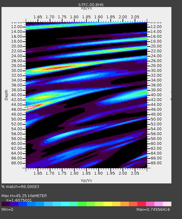
| Estimated Moho Depth: |
45.25 km |
| Estimated Crust Vp/Vs: |
1.61 |
| Assumed Crust Vp: |
6.552 km/s |
| Estimated Crust Vs: |
4.076 km/s |
| Estimated Crust Poisson's Ratio: |
0.18 |
|
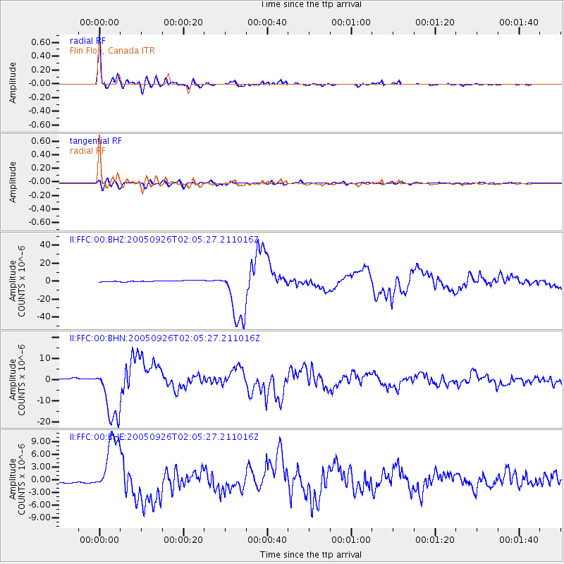
| Radial Match: |
98.08083 % |
| Radial Bump: |
400 |
| Transverse Match: |
89.8667 % |
| Transverse Bump: |
400 |
| SOD ConfigId: |
2475 |
| Insert Time: |
2010-03-01 19:59:23.975 +0000 |
| GWidth: |
2.5 |
| Max Bumps: |
400 |
| Tol: |
0.001 |
|
Signal To Noise
| Channel | StoN | STA | LTA |
| II:FFC:00:BHN:20050926T02:05:27.211016Z | 36.571167 | 1.3757737E-5 | 3.7619083E-7 |
| II:FFC:00:BHE:20050926T02:05:27.211016Z | 27.757942 | 7.1797876E-6 | 2.5865705E-7 |
| II:FFC:00:BHZ:20050926T02:05:27.211016Z | 54.14348 | 3.305528E-5 | 6.1051264E-7 |
| Arrivals |
| Ps | 4.4 SECOND |
| PpPs | 17 SECOND |
| PsPs/PpSs | 22 SECOND |


