You are here: Home > Network List > TA - USArray Transportable Network (new EarthScope stations) Stations List
> Station G59A Clarenceville, QC, USA > Earthquake Result Viewer
G59A Clarenceville, QC, USA - Earthquake Result Viewer
*The percent match for this event was below the threshold and hence no stack was calculated.
| Earthquake location: |
Near Coast Of Northern Chile |
| Earthquake latitude/longitude: |
-19.6/-70.8 |
| Earthquake time(UTC): |
2014/04/02 (092) 00:06:44 GMT |
| Earthquake Depth: |
10 km |
| Earthquake Magnitude: |
5.7 MB |
| Earthquake Catalog/Contributor: |
NEIC PDE/NEIC COMCAT |
|
| Network: |
TA USArray Transportable Network (new EarthScope stations) |
| Station: |
G59A Clarenceville, QC, USA |
| Lat/Lon: |
45.08 N/73.18 W |
| Elevation: |
36 m |
|
| Distance: |
64.4 deg |
| Az: |
358.137 deg |
| Baz: |
177.522 deg |
| Ray Param: |
$rayparam |
*The percent match for this event was below the threshold and hence was not used in the summary stack. |
|
| Radial Match: |
81.521935 % |
| Radial Bump: |
283 |
| Transverse Match: |
73.759705 % |
| Transverse Bump: |
400 |
| SOD ConfigId: |
626651 |
| Insert Time: |
2014-04-21 23:00:36.264 +0000 |
| GWidth: |
2.5 |
| Max Bumps: |
400 |
| Tol: |
0.001 |
|
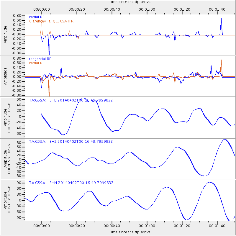
Signal To Noise
| Channel | StoN | STA | LTA |
| TA:G59A: :BHZ:20140402T00:16:49.799983Z | 1.2176126 | 1.4197859E-5 | 1.1660407E-5 |
| TA:G59A: :BHN:20140402T00:16:49.799983Z | 7.2195063 | 4.5006946E-5 | 6.234075E-6 |
| TA:G59A: :BHE:20140402T00:16:49.799983Z | 1.2642545 | 5.35085E-5 | 4.2324154E-5 |
| Arrivals |
| Ps | |
| PpPs | |
| PsPs/PpSs | |


