You are here: Home > Network List > TA - USArray Transportable Network (new EarthScope stations) Stations List
> Station M47A Cromwell, IN, USA > Earthquake Result Viewer
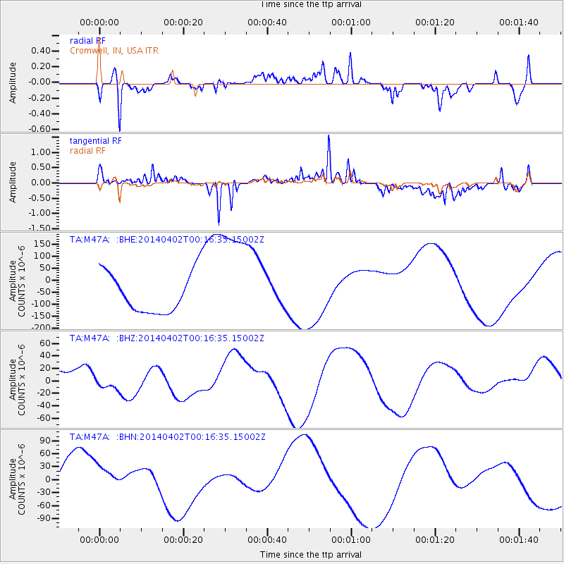
M47A Cromwell, IN, USA - Earthquake Result Viewer
*The percent match for this event was below the threshold and hence no stack was calculated.
| Earthquake location: |
Near Coast Of Northern Chile |
| Earthquake latitude/longitude: |
-19.6/-70.8 |
| Earthquake time(UTC): |
2014/04/02 (092) 00:06:44 GMT |
| Earthquake Depth: |
10 km |
| Earthquake Magnitude: |
5.7 MB |
| Earthquake Catalog/Contributor: |
NEIC PDE/NEIC COMCAT |
|
| Network: |
TA USArray Transportable Network (new EarthScope stations) |
| Station: |
M47A Cromwell, IN, USA |
| Lat/Lon: |
41.36 N/85.62 W |
| Elevation: |
283 m |
|
| Distance: |
62.2 deg |
| Az: |
347.436 deg |
| Baz: |
164.193 deg |
| Ray Param: |
$rayparam |
*The percent match for this event was below the threshold and hence was not used in the summary stack. |
|
| Radial Match: |
69.48372 % |
| Radial Bump: |
307 |
| Transverse Match: |
44.19554 % |
| Transverse Bump: |
278 |
| SOD ConfigId: |
626651 |
| Insert Time: |
2014-04-21 23:05:07.020 +0000 |
| GWidth: |
2.5 |
| Max Bumps: |
400 |
| Tol: |
0.001 |
|
Signal To Noise
| Channel | StoN | STA | LTA |
| TA:M47A: :BHZ:20140402T00:16:35.15002Z | 0.40172002 | 8.712974E-6 | 2.1689171E-5 |
| TA:M47A: :BHN:20140402T00:16:35.15002Z | 1.0113658 | 4.184941E-5 | 4.1379102E-5 |
| TA:M47A: :BHE:20140402T00:16:35.15002Z | 2.6366427 | 2.2552282E-4 | 8.5534084E-5 |
| Arrivals |
| Ps | |
| PpPs | |
| PsPs/PpSs | |


