You are here: Home > Network List > TA - USArray Transportable Network (new EarthScope stations) Stations List
> Station R53A Hurricane, WV, USA > Earthquake Result Viewer
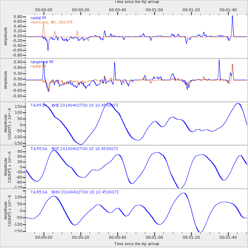
R53A Hurricane, WV, USA - Earthquake Result Viewer
*The percent match for this event was below the threshold and hence no stack was calculated.
| Earthquake location: |
Near Coast Of Northern Chile |
| Earthquake latitude/longitude: |
-19.6/-70.8 |
| Earthquake time(UTC): |
2014/04/02 (092) 00:06:44 GMT |
| Earthquake Depth: |
10 km |
| Earthquake Magnitude: |
5.7 MB |
| Earthquake Catalog/Contributor: |
NEIC PDE/NEIC COMCAT |
|
| Network: |
TA USArray Transportable Network (new EarthScope stations) |
| Station: |
R53A Hurricane, WV, USA |
| Lat/Lon: |
38.33 N/81.95 W |
| Elevation: |
294 m |
|
| Distance: |
58.6 deg |
| Az: |
349.742 deg |
| Baz: |
167.677 deg |
| Ray Param: |
$rayparam |
*The percent match for this event was below the threshold and hence was not used in the summary stack. |
|
| Radial Match: |
62.06369 % |
| Radial Bump: |
400 |
| Transverse Match: |
56.741295 % |
| Transverse Bump: |
400 |
| SOD ConfigId: |
626651 |
| Insert Time: |
2014-04-21 23:08:42.304 +0000 |
| GWidth: |
2.5 |
| Max Bumps: |
400 |
| Tol: |
0.001 |
|
Signal To Noise
| Channel | StoN | STA | LTA |
| TA:R53A: :BHZ:20140402T00:16:10.450007Z | 2.3233733 | 5.7892474E-5 | 2.4917423E-5 |
| TA:R53A: :BHN:20140402T00:16:10.450007Z | 2.4842758 | 8.7647706E-5 | 3.5280988E-5 |
| TA:R53A: :BHE:20140402T00:16:10.450007Z | 1.2676266 | 1.3798644E-4 | 1.0885417E-4 |
| Arrivals |
| Ps | |
| PpPs | |
| PsPs/PpSs | |


