You are here: Home > Network List > TA - USArray Transportable Network (new EarthScope stations) Stations List
> Station T51A Gray, KY, USA > Earthquake Result Viewer
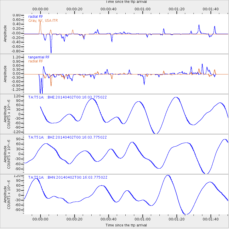
T51A Gray, KY, USA - Earthquake Result Viewer
*The percent match for this event was below the threshold and hence no stack was calculated.
| Earthquake location: |
Near Coast Of Northern Chile |
| Earthquake latitude/longitude: |
-19.6/-70.8 |
| Earthquake time(UTC): |
2014/04/02 (092) 00:06:44 GMT |
| Earthquake Depth: |
10 km |
| Earthquake Magnitude: |
5.7 MB |
| Earthquake Catalog/Contributor: |
NEIC PDE/NEIC COMCAT |
|
| Network: |
TA USArray Transportable Network (new EarthScope stations) |
| Station: |
T51A Gray, KY, USA |
| Lat/Lon: |
36.97 N/83.95 W |
| Elevation: |
329 m |
|
| Distance: |
57.6 deg |
| Az: |
347.555 deg |
| Baz: |
165.308 deg |
| Ray Param: |
$rayparam |
*The percent match for this event was below the threshold and hence was not used in the summary stack. |
|
| Radial Match: |
72.7311 % |
| Radial Bump: |
217 |
| Transverse Match: |
57.06523 % |
| Transverse Bump: |
296 |
| SOD ConfigId: |
626651 |
| Insert Time: |
2014-04-21 23:10:05.876 +0000 |
| GWidth: |
2.5 |
| Max Bumps: |
400 |
| Tol: |
0.001 |
|
Signal To Noise
| Channel | StoN | STA | LTA |
| TA:T51A: :BHZ:20140402T00:16:03.77502Z | 2.5151935 | 6.4904976E-5 | 2.5805162E-5 |
| TA:T51A: :BHN:20140402T00:16:03.77502Z | 1.2680032 | 5.5257144E-5 | 4.3578075E-5 |
| TA:T51A: :BHE:20140402T00:16:03.77502Z | 4.4479957 | 1.13828304E-4 | 2.559092E-5 |
| Arrivals |
| Ps | |
| PpPs | |
| PsPs/PpSs | |


