You are here: Home > Network List > TA - USArray Transportable Network (new EarthScope stations) Stations List
> Station X43A Marvell, AR, USA > Earthquake Result Viewer
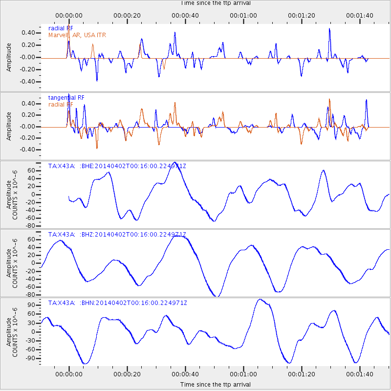
X43A Marvell, AR, USA - Earthquake Result Viewer
*The percent match for this event was below the threshold and hence no stack was calculated.
| Earthquake location: |
Near Coast Of Northern Chile |
| Earthquake latitude/longitude: |
-19.6/-70.8 |
| Earthquake time(UTC): |
2014/04/02 (092) 00:06:44 GMT |
| Earthquake Depth: |
10 km |
| Earthquake Magnitude: |
5.7 MB |
| Earthquake Catalog/Contributor: |
NEIC PDE/NEIC COMCAT |
|
| Network: |
TA USArray Transportable Network (new EarthScope stations) |
| Station: |
X43A Marvell, AR, USA |
| Lat/Lon: |
34.52 N/90.88 W |
| Elevation: |
53 m |
|
| Distance: |
57.1 deg |
| Az: |
340.281 deg |
| Baz: |
157.346 deg |
| Ray Param: |
$rayparam |
*The percent match for this event was below the threshold and hence was not used in the summary stack. |
|
| Radial Match: |
47.177456 % |
| Radial Bump: |
385 |
| Transverse Match: |
66.444695 % |
| Transverse Bump: |
400 |
| SOD ConfigId: |
626651 |
| Insert Time: |
2014-04-21 23:11:47.496 +0000 |
| GWidth: |
2.5 |
| Max Bumps: |
400 |
| Tol: |
0.001 |
|
Signal To Noise
| Channel | StoN | STA | LTA |
| TA:X43A: :BHZ:20140402T00:16:00.224971Z | 0.79376894 | 2.8219007E-5 | 3.5550653E-5 |
| TA:X43A: :BHN:20140402T00:16:00.224971Z | 1.799544 | 6.8710615E-5 | 3.8182236E-5 |
| TA:X43A: :BHE:20140402T00:16:00.224971Z | 1.1784518 | 4.5358272E-5 | 3.8489714E-5 |
| Arrivals |
| Ps | |
| PpPs | |
| PsPs/PpSs | |


