You are here: Home > Network List > TA - USArray Transportable Network (new EarthScope stations) Stations List
> Station G63A Kingsbury, ME, USA > Earthquake Result Viewer
G63A Kingsbury, ME, USA - Earthquake Result Viewer
| Earthquake location: |
Near Coast Of Northern Chile |
| Earthquake latitude/longitude: |
-19.9/-70.7 |
| Earthquake time(UTC): |
2014/04/02 (092) 00:24:45 GMT |
| Earthquake Depth: |
10 km |
| Earthquake Magnitude: |
5.6 MB |
| Earthquake Catalog/Contributor: |
NEIC PDE/NEIC COMCAT |
|
| Network: |
TA USArray Transportable Network (new EarthScope stations) |
| Station: |
G63A Kingsbury, ME, USA |
| Lat/Lon: |
45.11 N/69.62 W |
| Elevation: |
363 m |
|
| Distance: |
64.7 deg |
| Az: |
0.867 deg |
| Baz: |
181.152 deg |
| Ray Param: |
0.058744084 |
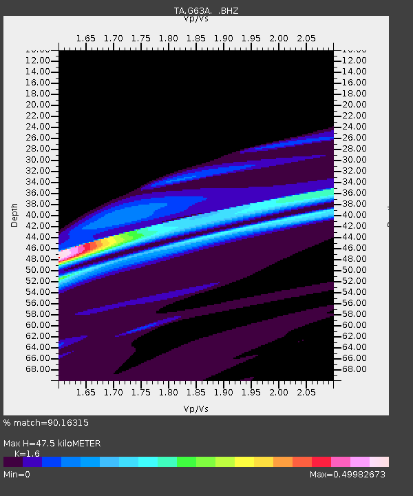
| Estimated Moho Depth: |
47.5 km |
| Estimated Crust Vp/Vs: |
1.60 |
| Assumed Crust Vp: |
6.419 km/s |
| Estimated Crust Vs: |
4.012 km/s |
| Estimated Crust Poisson's Ratio: |
0.18 |
|
| Radial Match: |
90.16315 % |
| Radial Bump: |
400 |
| Transverse Match: |
52.894096 % |
| Transverse Bump: |
232 |
| SOD ConfigId: |
626651 |
| Insert Time: |
2014-04-21 23:48:07.522 +0000 |
| GWidth: |
2.5 |
| Max Bumps: |
400 |
| Tol: |
0.001 |
|
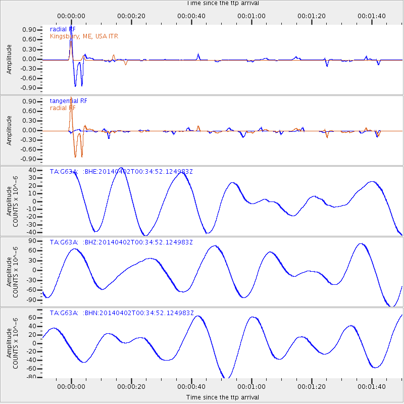
Signal To Noise
| Channel | StoN | STA | LTA |
| TA:G63A: :BHZ:20140402T00:34:52.124983Z | 1.3027146 | 6.786189E-5 | 5.2092673E-5 |
| TA:G63A: :BHN:20140402T00:34:52.124983Z | 1.5226997 | 3.202905E-5 | 2.1034382E-5 |
| TA:G63A: :BHE:20140402T00:34:52.124983Z | 0.6025086 | 1.7527109E-5 | 2.9090223E-5 |
| Arrivals |
| Ps | 4.7 SECOND |
| PpPs | 18 SECOND |
| PsPs/PpSs | 23 SECOND |


