You are here: Home > Network List > TA - USArray Transportable Network (new EarthScope stations) Stations List
> Station J61A Chester, VT, USA > Earthquake Result Viewer
J61A Chester, VT, USA - Earthquake Result Viewer
| Earthquake location: |
Near Coast Of Northern Chile |
| Earthquake latitude/longitude: |
-19.9/-70.7 |
| Earthquake time(UTC): |
2014/04/02 (092) 00:24:45 GMT |
| Earthquake Depth: |
10 km |
| Earthquake Magnitude: |
5.6 MB |
| Earthquake Catalog/Contributor: |
NEIC PDE/NEIC COMCAT |
|
| Network: |
TA USArray Transportable Network (new EarthScope stations) |
| Station: |
J61A Chester, VT, USA |
| Lat/Lon: |
43.35 N/72.55 W |
| Elevation: |
253 m |
|
| Distance: |
63.0 deg |
| Az: |
358.503 deg |
| Baz: |
178.069 deg |
| Ray Param: |
0.059885025 |
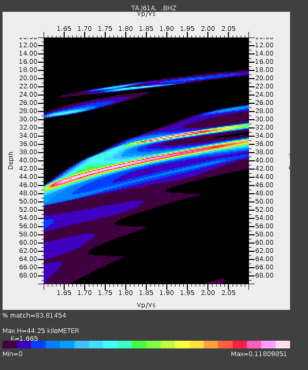
| Estimated Moho Depth: |
44.25 km |
| Estimated Crust Vp/Vs: |
1.66 |
| Assumed Crust Vp: |
6.419 km/s |
| Estimated Crust Vs: |
3.855 km/s |
| Estimated Crust Poisson's Ratio: |
0.22 |
|
| Radial Match: |
83.81454 % |
| Radial Bump: |
400 |
| Transverse Match: |
51.463154 % |
| Transverse Bump: |
316 |
| SOD ConfigId: |
626651 |
| Insert Time: |
2014-04-21 23:50:05.585 +0000 |
| GWidth: |
2.5 |
| Max Bumps: |
400 |
| Tol: |
0.001 |
|
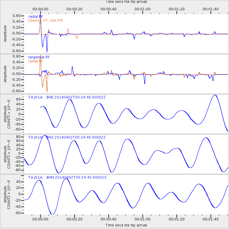
Signal To Noise
| Channel | StoN | STA | LTA |
| TA:J61A: :BHZ:20140402T00:34:40.60002Z | 4.0034556 | 8.0423546E-5 | 2.0088533E-5 |
| TA:J61A: :BHN:20140402T00:34:40.60002Z | 2.6282618 | 3.3504657E-5 | 1.2747838E-5 |
| TA:J61A: :BHE:20140402T00:34:40.60002Z | 0.81549513 | 2.923449E-5 | 3.5848763E-5 |
| Arrivals |
| Ps | 4.8 SECOND |
| PpPs | 18 SECOND |
| PsPs/PpSs | 22 SECOND |


