You are here: Home > Network List > TA - USArray Transportable Network (new EarthScope stations) Stations List
> Station P51A Williamsport, OH, USA > Earthquake Result Viewer
P51A Williamsport, OH, USA - Earthquake Result Viewer

| Earthquake location: |
Near Coast Of Northern Chile |
| Earthquake latitude/longitude: |
-19.9/-70.7 |
| Earthquake time(UTC): |
2014/04/02 (092) 00:24:45 GMT |
| Earthquake Depth: |
10 km |
| Earthquake Magnitude: |
5.6 MB |
| Earthquake Catalog/Contributor: |
NEIC PDE/NEIC COMCAT |
|
| Network: |
TA USArray Transportable Network (new EarthScope stations) |
| Station: |
P51A Williamsport, OH, USA |
| Lat/Lon: |
39.48 N/83.06 W |
| Elevation: |
211 m |
|
| Distance: |
60.2 deg |
| Az: |
349.016 deg |
| Baz: |
166.606 deg |
| Ray Param: |
0.061692957 |
| Estimated Moho Depth: |
66.0 km |
| Estimated Crust Vp/Vs: |
1.75 |
| Assumed Crust Vp: |
6.232 km/s |
| Estimated Crust Vs: |
3.566 km/s |
| Estimated Crust Poisson's Ratio: |
0.26 |
|
| Radial Match: |
83.75682 % |
| Radial Bump: |
400 |
| Transverse Match: |
54.217876 % |
| Transverse Bump: |
285 |
| SOD ConfigId: |
626651 |
| Insert Time: |
2014-04-21 23:54:14.207 +0000 |
| GWidth: |
2.5 |
| Max Bumps: |
400 |
| Tol: |
0.001 |
|
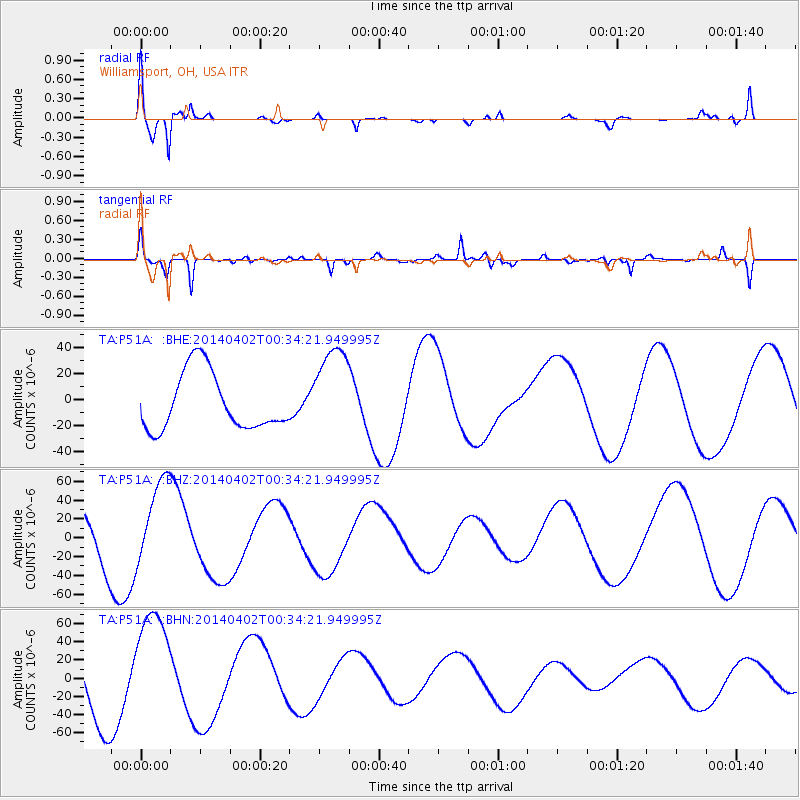
Signal To Noise
| Channel | StoN | STA | LTA |
| TA:P51A: :BHZ:20140402T00:34:21.949995Z | 1.999624 | 4.7371163E-5 | 2.3690034E-5 |
| TA:P51A: :BHN:20140402T00:34:21.949995Z | 2.3136132 | 6.241286E-5 | 2.6976359E-5 |
| TA:P51A: :BHE:20140402T00:34:21.949995Z | 1.6504785 | 3.657672E-5 | 2.2161283E-5 |
| Arrivals |
| Ps | 8.3 SECOND |
| PpPs | 28 SECOND |
| PsPs/PpSs | 36 SECOND |


