You are here: Home > Network List > TA - USArray Transportable Network (new EarthScope stations) Stations List
> Station V60A Jim Taylor Road, Stokes, NC, USA > Earthquake Result Viewer
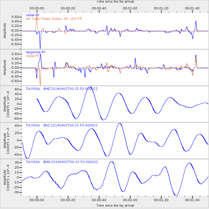
V60A Jim Taylor Road, Stokes, NC, USA - Earthquake Result Viewer
*The percent match for this event was below the threshold and hence no stack was calculated.
| Earthquake location: |
Near Coast Of Northern Chile |
| Earthquake latitude/longitude: |
-19.9/-70.7 |
| Earthquake time(UTC): |
2014/04/02 (092) 00:24:45 GMT |
| Earthquake Depth: |
10 km |
| Earthquake Magnitude: |
5.6 MB |
| Earthquake Catalog/Contributor: |
NEIC PDE/NEIC COMCAT |
|
| Network: |
TA USArray Transportable Network (new EarthScope stations) |
| Station: |
V60A Jim Taylor Road, Stokes, NC, USA |
| Lat/Lon: |
35.76 N/77.26 W |
| Elevation: |
8.0 m |
|
| Distance: |
55.7 deg |
| Az: |
353.566 deg |
| Baz: |
172.55 deg |
| Ray Param: |
$rayparam |
*The percent match for this event was below the threshold and hence was not used in the summary stack. |
|
| Radial Match: |
82.793976 % |
| Radial Bump: |
400 |
| Transverse Match: |
52.6519 % |
| Transverse Bump: |
299 |
| SOD ConfigId: |
626651 |
| Insert Time: |
2014-04-21 23:57:22.117 +0000 |
| GWidth: |
2.5 |
| Max Bumps: |
400 |
| Tol: |
0.001 |
|
Signal To Noise
| Channel | StoN | STA | LTA |
| TA:V60A: :BHZ:20140402T00:33:50.60002Z | 0.96949315 | 2.3453911E-5 | 2.419193E-5 |
| TA:V60A: :BHN:20140402T00:33:50.60002Z | 0.40294957 | 6.816619E-6 | 1.6916805E-5 |
| TA:V60A: :BHE:20140402T00:33:50.60002Z | 2.104236 | 5.3104417E-5 | 2.5236914E-5 |
| Arrivals |
| Ps | |
| PpPs | |
| PsPs/PpSs | |


