You are here: Home > Network List > II - Global Seismograph Network (GSN - IRIS/IDA) Stations List
> Station FFC Flin Flon, Canada > Earthquake Result Viewer
FFC Flin Flon, Canada - Earthquake Result Viewer
| Earthquake location: |
Tonga Islands |
| Earthquake latitude/longitude: |
-21.9/-173.8 |
| Earthquake time(UTC): |
2008/10/19 (293) 05:10:33 GMT |
| Earthquake Depth: |
29 km |
| Earthquake Magnitude: |
6.8 MB, 7.0 MS, 6.9 MW, 6.9 MW |
| Earthquake Catalog/Contributor: |
WHDF/NEIC |
|
| Network: |
II Global Seismograph Network (GSN - IRIS/IDA) |
| Station: |
FFC Flin Flon, Canada |
| Lat/Lon: |
54.72 N/101.98 W |
| Elevation: |
338 m |
|
| Distance: |
97.7 deg |
| Az: |
33.792 deg |
| Baz: |
242.956 deg |
| Ray Param: |
0.04012814 |
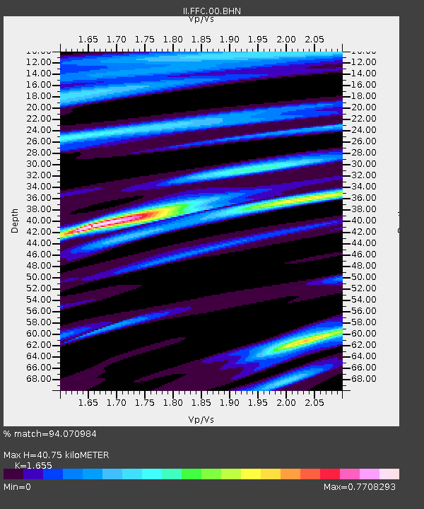
| Estimated Moho Depth: |
40.75 km |
| Estimated Crust Vp/Vs: |
1.65 |
| Assumed Crust Vp: |
6.552 km/s |
| Estimated Crust Vs: |
3.959 km/s |
| Estimated Crust Poisson's Ratio: |
0.21 |
|
| Radial Match: |
94.070984 % |
| Radial Bump: |
312 |
| Transverse Match: |
78.785805 % |
| Transverse Bump: |
381 |
| SOD ConfigId: |
2556 |
| Insert Time: |
2010-03-01 20:00:40.987 +0000 |
| GWidth: |
2.5 |
| Max Bumps: |
400 |
| Tol: |
0.001 |
|
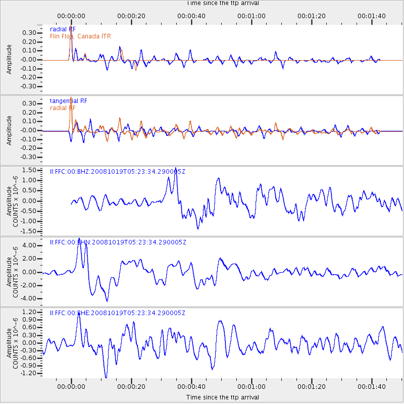
Signal To Noise
| Channel | StoN | STA | LTA |
| II:FFC:00:BHN:20081019T05:23:34.290005Z | 14.928515 | 2.5506642E-6 | 1.7085853E-7 |
| II:FFC:00:BHE:20081019T05:23:34.290005Z | 3.3259578 | 5.2960434E-7 | 1.5923362E-7 |
| II:FFC:00:BHZ:20081019T05:23:34.290005Z | 4.234276 | 7.5079333E-7 | 1.7731328E-7 |
| Arrivals |
| Ps | 4.2 SECOND |
| PpPs | 16 SECOND |
| PsPs/PpSs | 20 SECOND |


