You are here: Home > Network List > TA - USArray Transportable Network (new EarthScope stations) Stations List
> Station J48A Bridge Port, MI, USA > Earthquake Result Viewer
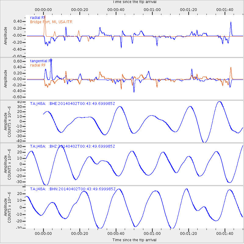
J48A Bridge Port, MI, USA - Earthquake Result Viewer
*The percent match for this event was below the threshold and hence no stack was calculated.
| Earthquake location: |
Near Coast Of Northern Chile |
| Earthquake latitude/longitude: |
-20.2/-70.7 |
| Earthquake time(UTC): |
2014/04/02 (092) 00:33:45 GMT |
| Earthquake Depth: |
13 km |
| Earthquake Magnitude: |
5.5 MB |
| Earthquake Catalog/Contributor: |
NEIC PDE/NEIC COMCAT |
|
| Network: |
TA USArray Transportable Network (new EarthScope stations) |
| Station: |
J48A Bridge Port, MI, USA |
| Lat/Lon: |
43.30 N/82.78 W |
| Elevation: |
195 m |
|
| Distance: |
64.2 deg |
| Az: |
350.216 deg |
| Baz: |
167.376 deg |
| Ray Param: |
$rayparam |
*The percent match for this event was below the threshold and hence was not used in the summary stack. |
|
| Radial Match: |
81.33017 % |
| Radial Bump: |
400 |
| Transverse Match: |
78.86814 % |
| Transverse Bump: |
291 |
| SOD ConfigId: |
626651 |
| Insert Time: |
2014-04-22 00:36:50.220 +0000 |
| GWidth: |
2.5 |
| Max Bumps: |
400 |
| Tol: |
0.001 |
|
Signal To Noise
| Channel | StoN | STA | LTA |
| TA:J48A: :BHZ:20140402T00:43:49.699985Z | 3.6748781 | 3.1913805E-5 | 8.6843165E-6 |
| TA:J48A: :BHN:20140402T00:43:49.699985Z | 0.8351175 | 6.6535563E-6 | 7.967209E-6 |
| TA:J48A: :BHE:20140402T00:43:49.699985Z | 1.3433025 | 1.7558645E-5 | 1.3071252E-5 |
| Arrivals |
| Ps | |
| PpPs | |
| PsPs/PpSs | |


