You are here: Home > Network List > TA - USArray Transportable Network (new EarthScope stations) Stations List
> Station P59A Jarrettsville, MD, USA > Earthquake Result Viewer
P59A Jarrettsville, MD, USA - Earthquake Result Viewer
| Earthquake location: |
Near Coast Of Northern Chile |
| Earthquake latitude/longitude: |
-20.2/-70.7 |
| Earthquake time(UTC): |
2014/04/02 (092) 00:33:45 GMT |
| Earthquake Depth: |
13 km |
| Earthquake Magnitude: |
5.5 MB |
| Earthquake Catalog/Contributor: |
NEIC PDE/NEIC COMCAT |
|
| Network: |
TA USArray Transportable Network (new EarthScope stations) |
| Station: |
P59A Jarrettsville, MD, USA |
| Lat/Lon: |
39.61 N/76.43 W |
| Elevation: |
157 m |
|
| Distance: |
59.8 deg |
| Az: |
354.866 deg |
| Baz: |
173.756 deg |
| Ray Param: |
0.061952755 |
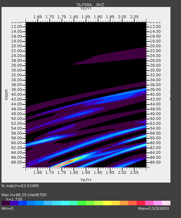
| Estimated Moho Depth: |
69.25 km |
| Estimated Crust Vp/Vs: |
1.74 |
| Assumed Crust Vp: |
6.419 km/s |
| Estimated Crust Vs: |
3.7 km/s |
| Estimated Crust Poisson's Ratio: |
0.25 |
|
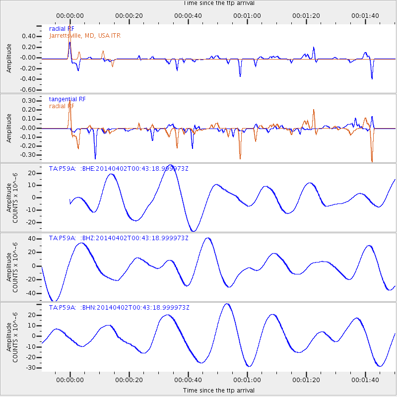
| Radial Match: |
83.03495 % |
| Radial Bump: |
365 |
| Transverse Match: |
52.55244 % |
| Transverse Bump: |
339 |
| SOD ConfigId: |
626651 |
| Insert Time: |
2014-04-22 00:42:01.549 +0000 |
| GWidth: |
2.5 |
| Max Bumps: |
400 |
| Tol: |
0.001 |
|
Signal To Noise
| Channel | StoN | STA | LTA |
| TA:P59A: :BHZ:20140402T00:43:18.999973Z | 0.79574233 | 2.6805634E-5 | 3.3686323E-5 |
| TA:P59A: :BHN:20140402T00:43:18.999973Z | 0.4397258 | 4.7529284E-6 | 1.0808846E-5 |
| TA:P59A: :BHE:20140402T00:43:18.999973Z | 1.9246298 | 2.2164886E-5 | 1.1516441E-5 |
| Arrivals |
| Ps | 8.3 SECOND |
| PpPs | 28 SECOND |
| PsPs/PpSs | 36 SECOND |


