You are here: Home > Network List > TJ - Tajikistan National Seismic Network Stations List
> Station SHAA Shaartuz, Tajikistan > Earthquake Result Viewer
SHAA Shaartuz, Tajikistan - Earthquake Result Viewer
| Earthquake location: |
Mariana Islands Region |
| Earthquake latitude/longitude: |
15.3/147.1 |
| Earthquake time(UTC): |
2015/01/31 (031) 12:29:31 GMT |
| Earthquake Depth: |
10 km |
| Earthquake Magnitude: |
5.7 MO |
| Earthquake Catalog/Contributor: |
NEIC PDE/NEIC ALERT |
|
| Network: |
TJ Tajikistan National Seismic Network |
| Station: |
SHAA Shaartuz, Tajikistan |
| Lat/Lon: |
37.56 N/68.12 E |
| Elevation: |
868 m |
|
| Distance: |
72.2 deg |
| Az: |
304.996 deg |
| Baz: |
84.201 deg |
| Ray Param: |
0.053810533 |
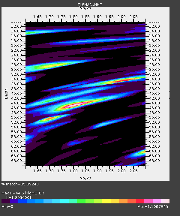
| Estimated Moho Depth: |
44.5 km |
| Estimated Crust Vp/Vs: |
1.81 |
| Assumed Crust Vp: |
6.213 km/s |
| Estimated Crust Vs: |
3.442 km/s |
| Estimated Crust Poisson's Ratio: |
0.28 |
|
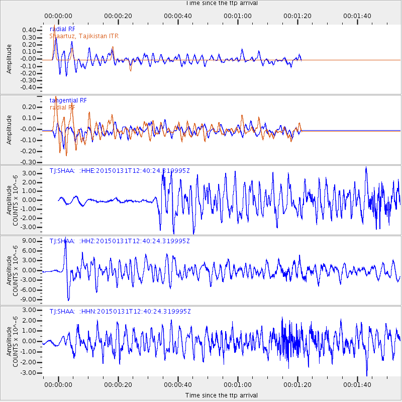
| Radial Match: |
85.09243 % |
| Radial Bump: |
400 |
| Transverse Match: |
77.849976 % |
| Transverse Bump: |
400 |
| SOD ConfigId: |
3390531 |
| Insert Time: |
2019-04-16 06:11:52.382 +0000 |
| GWidth: |
2.5 |
| Max Bumps: |
400 |
| Tol: |
0.001 |
|
Signal To Noise
| Channel | StoN | STA | LTA |
| TJ:SHAA: :HHZ:20150131T12:40:24.319995Z | 14.937324 | 4.103545E-6 | 2.7471756E-7 |
| TJ:SHAA: :HHN:20150131T12:40:24.319995Z | 1.8915495 | 4.237409E-7 | 2.2401787E-7 |
| TJ:SHAA: :HHE:20150131T12:40:24.319995Z | 6.7945848 | 1.4736503E-6 | 2.16886E-7 |
| Arrivals |
| Ps | 6.0 SECOND |
| PpPs | 19 SECOND |
| PsPs/PpSs | 25 SECOND |


