You are here: Home > Network List > TA - USArray Transportable Network (new EarthScope stations) Stations List
> Station J04D Umpqua National Forest, Toketee, OR, USA > Earthquake Result Viewer
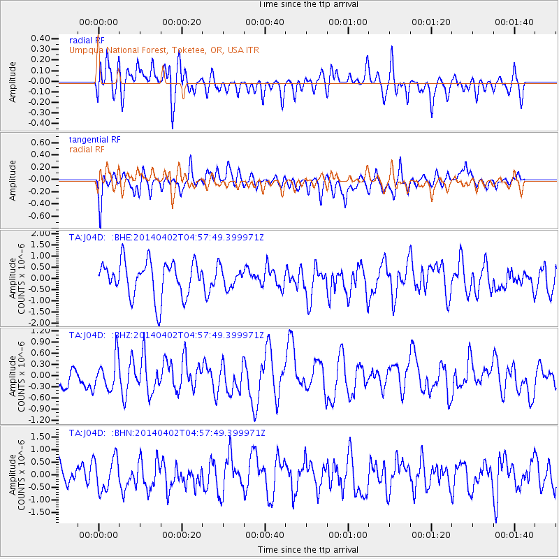
J04D Umpqua National Forest, Toketee, OR, USA - Earthquake Result Viewer
*The percent match for this event was below the threshold and hence no stack was calculated.
| Earthquake location: |
Near Coast Of Northern Chile |
| Earthquake latitude/longitude: |
-20.2/-70.9 |
| Earthquake time(UTC): |
2014/04/02 (092) 04:46:18 GMT |
| Earthquake Depth: |
10 km |
| Earthquake Magnitude: |
5.8 MB |
| Earthquake Catalog/Contributor: |
NEIC PDE/NEIC COMCAT |
|
| Network: |
TA USArray Transportable Network (new EarthScope stations) |
| Station: |
J04D Umpqua National Forest, Toketee, OR, USA |
| Lat/Lon: |
43.24 N/122.11 W |
| Elevation: |
1948 m |
|
| Distance: |
78.7 deg |
| Az: |
324.462 deg |
| Baz: |
131.645 deg |
| Ray Param: |
$rayparam |
*The percent match for this event was below the threshold and hence was not used in the summary stack. |
|
| Radial Match: |
44.666786 % |
| Radial Bump: |
400 |
| Transverse Match: |
56.38806 % |
| Transverse Bump: |
400 |
| SOD ConfigId: |
626651 |
| Insert Time: |
2014-04-22 01:20:34.598 +0000 |
| GWidth: |
2.5 |
| Max Bumps: |
400 |
| Tol: |
0.001 |
|
Signal To Noise
| Channel | StoN | STA | LTA |
| TA:J04D: :BHZ:20140402T04:57:49.399971Z | 1.0953625 | 4.2729582E-7 | 3.9009535E-7 |
| TA:J04D: :BHN:20140402T04:57:49.399971Z | 1.2265756 | 6.6494937E-7 | 5.421185E-7 |
| TA:J04D: :BHE:20140402T04:57:49.399971Z | 0.5290575 | 4.1690708E-7 | 7.880185E-7 |
| Arrivals |
| Ps | |
| PpPs | |
| PsPs/PpSs | |


