You are here: Home > Network List > UW - Pacific Northwest Regional Seismic Network Stations List
> Station MRBL Marblemount, WA, USA > Earthquake Result Viewer
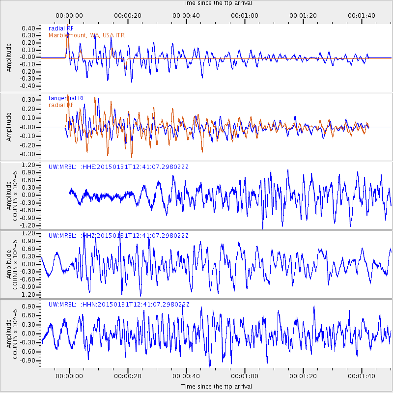
MRBL Marblemount, WA, USA - Earthquake Result Viewer
*The percent match for this event was below the threshold and hence no stack was calculated.
| Earthquake location: |
Mariana Islands Region |
| Earthquake latitude/longitude: |
15.3/147.1 |
| Earthquake time(UTC): |
2015/01/31 (031) 12:29:31 GMT |
| Earthquake Depth: |
10 km |
| Earthquake Magnitude: |
5.7 MO |
| Earthquake Catalog/Contributor: |
NEIC PDE/NEIC ALERT |
|
| Network: |
UW Pacific Northwest Regional Seismic Network |
| Station: |
MRBL Marblemount, WA, USA |
| Lat/Lon: |
48.52 N/121.48 W |
| Elevation: |
75 m |
|
| Distance: |
79.6 deg |
| Az: |
42.508 deg |
| Baz: |
281.244 deg |
| Ray Param: |
$rayparam |
*The percent match for this event was below the threshold and hence was not used in the summary stack. |
|
| Radial Match: |
75.66992 % |
| Radial Bump: |
400 |
| Transverse Match: |
61.28017 % |
| Transverse Bump: |
400 |
| SOD ConfigId: |
3390531 |
| Insert Time: |
2019-04-16 06:12:39.265 +0000 |
| GWidth: |
2.5 |
| Max Bumps: |
400 |
| Tol: |
0.001 |
|
Signal To Noise
| Channel | StoN | STA | LTA |
| UW:MRBL: :HHZ:20150131T12:41:07.298022Z | 1.732323 | 3.242805E-7 | 1.87194E-7 |
| UW:MRBL: :HHN:20150131T12:41:07.298022Z | 1.8012193 | 3.473637E-7 | 1.928492E-7 |
| UW:MRBL: :HHE:20150131T12:41:07.298022Z | 2.7644145 | 3.8984703E-7 | 1.4102336E-7 |
| Arrivals |
| Ps | |
| PpPs | |
| PsPs/PpSs | |


