You are here: Home > Network List > UW - Pacific Northwest Regional Seismic Network Stations List
> Station WOLL Wollman Farm, Schrag, WA, USA > Earthquake Result Viewer
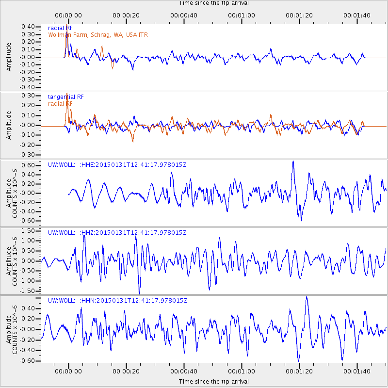
WOLL Wollman Farm, Schrag, WA, USA - Earthquake Result Viewer
*The percent match for this event was below the threshold and hence no stack was calculated.
| Earthquake location: |
Mariana Islands Region |
| Earthquake latitude/longitude: |
15.3/147.1 |
| Earthquake time(UTC): |
2015/01/31 (031) 12:29:31 GMT |
| Earthquake Depth: |
10 km |
| Earthquake Magnitude: |
5.7 MO |
| Earthquake Catalog/Contributor: |
NEIC PDE/NEIC ALERT |
|
| Network: |
UW Pacific Northwest Regional Seismic Network |
| Station: |
WOLL Wollman Farm, Schrag, WA, USA |
| Lat/Lon: |
47.06 N/118.92 W |
| Elevation: |
385 m |
|
| Distance: |
81.6 deg |
| Az: |
43.583 deg |
| Baz: |
283.312 deg |
| Ray Param: |
$rayparam |
*The percent match for this event was below the threshold and hence was not used in the summary stack. |
|
| Radial Match: |
62.339462 % |
| Radial Bump: |
400 |
| Transverse Match: |
40.87371 % |
| Transverse Bump: |
400 |
| SOD ConfigId: |
3390531 |
| Insert Time: |
2019-04-16 06:12:44.753 +0000 |
| GWidth: |
2.5 |
| Max Bumps: |
400 |
| Tol: |
0.001 |
|
Signal To Noise
| Channel | StoN | STA | LTA |
| UW:WOLL: :HHZ:20150131T12:41:17.978015Z | 2.5484016 | 4.4006603E-7 | 1.7268316E-7 |
| UW:WOLL: :HHN:20150131T12:41:17.978015Z | 1.2558998 | 1.9320785E-7 | 1.5384018E-7 |
| UW:WOLL: :HHE:20150131T12:41:17.978015Z | 0.8987865 | 1.1650294E-7 | 1.2962248E-7 |
| Arrivals |
| Ps | |
| PpPs | |
| PsPs/PpSs | |


